IMAGES TAKEN NEAR TO
Gors Road, ABERGELE, LL22 9LU
Introduction
This page details the photographs taken nearby to Gors Road, LL22 9LU by members of the Geograph project.
The Geograph project started in 2005 with the aim of publishing, organising and preserving representative images for every square kilometre of Great Britain, Ireland and the Isle of Man.

There are currently over 7.5m images from over14,400 individuals and you can help contribute to the project by visiting https://www.geograph.org.uk
Image Map
Images are licensed for reuse under creativecommons.org/licenses/by-sa/2.0
Notes
- Clicking on the map will re-center to the selected point.
- The higher the marker number, the further away the image location is from the centre of the postcode.
Image Listing (5 Images Found)
Images are licensed for reuse under creativecommons.org/licenses/by-sa/2.0
Image
Details
Distance
1
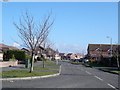
Towyn
One of several new housing estates in Towyn
Image: © Dot Potter
Taken: 20 Feb 2006
0.08 miles
2
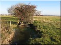
Frozen drain, Gors Road
The red berries on this ancient hawthorn tree make a fine sight over a frozen drain on a bright, frosty morning.
Image: © Jonathan Wilkins
Taken: 25 Nov 2016
0.14 miles
3
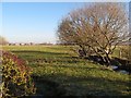
Drain with willow trees
Willows overhang a frozen drain on the Morfa Rhuddlan near to Gors, while a crop of haws enliven the nearby hedge.
Image: © Jonathan Wilkins
Taken: 25 Nov 2016
0.14 miles
4
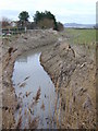
River Gele.
Abergele got its name because of this murky ditch.
Looking east from the road bridge.
Image: © Stephen Charles
Taken: 27 Jan 2006
0.15 miles
5
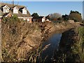
Afon Gele, Gors Road
Houses backing onto the Afon Gele on the outskirts of Towyn.
Image: © Jonathan Wilkins
Taken: 25 Nov 2016
0.19 miles