IMAGES TAKEN NEAR TO
Groesffordd Marli, ABERGELE, LL22 9ED
Introduction
This page details the photographs taken nearby to LL22 9ED by members of the Geograph project.
The Geograph project started in 2005 with the aim of publishing, organising and preserving representative images for every square kilometre of Great Britain, Ireland and the Isle of Man.

There are currently over 7.5m images from over14,400 individuals and you can help contribute to the project by visiting https://www.geograph.org.uk
Image Map
Images are licensed for reuse under creativecommons.org/licenses/by-sa/2.0
Notes
- Clicking on the map will re-center to the selected point.
- The higher the marker number, the further away the image location is from the centre of the postcode.
Image Listing (5 Images Found)
Images are licensed for reuse under creativecommons.org/licenses/by-sa/2.0
Image
Details
Distance
1
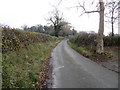
Minor road at Cae Onnen
Looking south-westward.
Image: © Peter Wood
Taken: 21 Nov 2018
0.17 miles
2
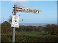
Arwydd ffordd o bren / A wooden road sign
The direction to St Asaph appears only in Welsh. The rust bands on the pole suggest that, at one time, the English directional sign was displayed underneath.
Image: © Ceri Thomas
Taken: 31 Oct 2009
0.20 miles
3
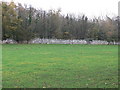
Cefn Meiriadog farmland
with a dry stone wall boundary
Image: © Eirian Evans
Taken: 16 Nov 2007
0.21 miles
5
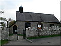
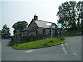
All Saint's Church, Sinan
Opened in 1873 on All Saints Day, this small stone church was built for an original cost of £215.
Image: © Eirian Evans
Taken: 16 Nov 2007
0.22 miles