IMAGES TAKEN NEAR TO
Groesffordd Marli, ABERGELE, LL22 9EA
Introduction
This page details the photographs taken nearby to LL22 9EA by members of the Geograph project.
The Geograph project started in 2005 with the aim of publishing, organising and preserving representative images for every square kilometre of Great Britain, Ireland and the Isle of Man.

There are currently over 7.5m images from over14,400 individuals and you can help contribute to the project by visiting https://www.geograph.org.uk
Image Map (Loading...)


Getting Data...Please wait
Leaflet Map data © OpenStreetMap
Images are licensed for reuse under creativecommons.org/licenses/by-sa/2.0
Notes
- Clicking on the map will re-center to the selected point.
- The higher the marker number, the further away the image location is from the centre of the postcode.
Image Listing (7 Images Found)
Images are licensed for reuse under creativecommons.org/licenses/by-sa/2.0
Image
Details
Distance
1
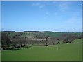
Tan y gaer
Fields near the farm of Tan y gaer
Image: © Dot Potter
Taken: 23 Apr 2006
0.08 miles
2
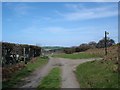
Gated road
A gated road on Mynydd y Gaer. Fairly typical in this area gates are always unlocked and need to be opened and closed when passing through to keep livestock within their boundaries.
Image: © Dot Potter
Taken: 23 Apr 2006
0.11 miles
3
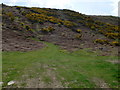
Mynydd y Gaer
Steep bracken and gorse covered northern flank of Mynydd y Gaer.
Image: © Eirian Evans
Taken: 29 Apr 2008
0.14 miles
5
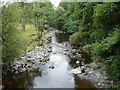
Part of the Afon Elwy
Viewed from the footbridge near Meifod Mill.
Image: © Jeremy Bolwell
Taken: 17 Jul 2010
0.22 miles
6
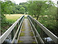
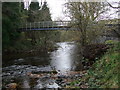
Footbridge over the Afon Elwy
This impressive footbridge leads across the meadow towards Meifod Mill, now a house.
Image: © Jeremy Bolwell
Taken: 17 Jul 2010
0.24 miles
7
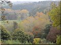
Lliwiau'r Hydref yn Nyffryn Elwy / Autumn colours in Dyffryn Elwy (4)
Image: © Ceri Thomas
Taken: 30 Oct 2016
0.24 miles