IMAGES TAKEN NEAR TO
Lon Elfod, ABERGELE, LL22 9BQ
Introduction
This page details the photographs taken nearby to Lon Elfod, LL22 9BQ by members of the Geograph project.
The Geograph project started in 2005 with the aim of publishing, organising and preserving representative images for every square kilometre of Great Britain, Ireland and the Isle of Man.

There are currently over 7.5m images from over14,400 individuals and you can help contribute to the project by visiting https://www.geograph.org.uk
Image Map (Loading...)


Getting Data...Please wait
Leaflet Map data © OpenStreetMap
Images are licensed for reuse under creativecommons.org/licenses/by-sa/2.0
Notes
- Clicking on the map will re-center to the selected point.
- The higher the marker number, the further away the image location is from the centre of the postcode.
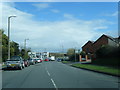
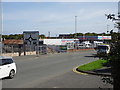
Image Listing (5 Images Found)
Images are licensed for reuse under creativecommons.org/licenses/by-sa/2.0
Image
Details
Distance
1
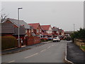
Estate of houses at Hendre Las, Abergele
Image: © Eirian Evans
Taken: 9 Mar 2020
0.06 miles

5
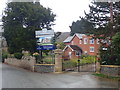
Gainsborough Park, Abergele
The large Gate House at the entrance to the park is an apartment block of six apartments. The estate is south-east of the town centre
Image: © Eirian Evans
Taken: 9 Mar 2020
0.24 miles