IMAGES TAKEN NEAR TO
Holland Drive, ABERGELE, LL22 9AF
Introduction
This page details the photographs taken nearby to Holland Drive, LL22 9AF by members of the Geograph project.
The Geograph project started in 2005 with the aim of publishing, organising and preserving representative images for every square kilometre of Great Britain, Ireland and the Isle of Man.

There are currently over 7.5m images from over14,400 individuals and you can help contribute to the project by visiting https://www.geograph.org.uk
Image Map
Images are licensed for reuse under creativecommons.org/licenses/by-sa/2.0
Notes
- Clicking on the map will re-center to the selected point.
- The higher the marker number, the further away the image location is from the centre of the postcode.
Image Listing (18 Images Found)
Images are licensed for reuse under creativecommons.org/licenses/by-sa/2.0
Image
Details
Distance
1
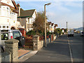
Holland Drive
A residential street in the district known as Belgrano.
Image: © Jonathan Wilkins
Taken: 18 Sep 2008
0.02 miles
2
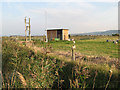
Pumping station
Situated at a junction on the network of drainage ditches that cross the Morfa Gele.
Image: © Jonathan Wilkins
Taken: 18 Sep 2008
0.12 miles
3
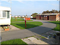
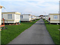
Caravan site
Communal areas in one of the many permanent sites along this part of the coast.
Image: © Jonathan Wilkins
Taken: 18 Sep 2008
0.13 miles
5
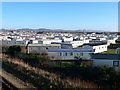
Caravan park
Regular ranks of permanent caravans between the coast road and the railway. The caravans are surprisingly varied - there are two the same in this view - can you spot them?
Image: © Jonathan Wilkins
Taken: 18 Sep 2008
0.16 miles
6
Home from home
One of the many caravan parks along the coast between Towyn and Abergele
Image: © Eirian Evans
Taken: 6 Dec 2008
0.16 miles
7
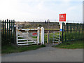
Stop, look, listen
A pedestrian crossing over the Chester to Holyhead railway line. Access to the sea and the beach is surprisingly restricted for an area with such a high number of caravans. However the possibility of caravans in the area is largely down to the railway which was created on an embankment with a sea wall, thus allowing the drainage of the marshy hinterland. Failure of the sea wall near to this point was responsible for the flooding of the area in 1990.
Image: © Jonathan Wilkins
Taken: 18 Sep 2008
0.17 miles
8
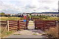
Railway Crossing at Belgrano
A crossing on the North Wales Coast Line at Belgrano.
Image: © Jeff Buck
Taken: 24 Aug 2015
0.20 miles
9
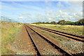
The North Wales Coast Line at Belgrano
The North Wales Coast Line heading east at Belgrano near Abergele.
Image: © Jeff Buck
Taken: 24 Aug 2015
0.20 miles
10
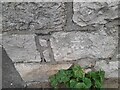
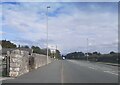
Ordnance Survey Cut Mark
This OS cut mark can be found on the wall NW side of Towyn Road. It marks a point 5.904m above mean sea level.
Image: © Adrian Dust
Taken: 28 Mar 2023
0.20 miles