IMAGES TAKEN NEAR TO
Towyn Road, ABERGELE, LL22 9AD
Introduction
This page details the photographs taken nearby to Towyn Road, LL22 9AD by members of the Geograph project.
The Geograph project started in 2005 with the aim of publishing, organising and preserving representative images for every square kilometre of Great Britain, Ireland and the Isle of Man.

There are currently over 7.5m images from over14,400 individuals and you can help contribute to the project by visiting https://www.geograph.org.uk
Image Map
Images are licensed for reuse under creativecommons.org/licenses/by-sa/2.0
Notes
- Clicking on the map will re-center to the selected point.
- The higher the marker number, the further away the image location is from the centre of the postcode.
Image Listing (30 Images Found)
Images are licensed for reuse under creativecommons.org/licenses/by-sa/2.0
Image
Details
Distance
1
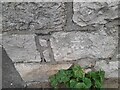
Ordnance Survey Cut Mark
This OS cut mark can be found on the wall NW side of Towyn Road. It marks a point 5.904m above mean sea level.
Image: © Adrian Dust
Taken: 28 Mar 2023
0.02 miles
2
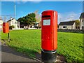
Postbox at Belgrano
LL22 148. Royal Mail list this box as 'Rhos Fawr'.
Image: © David Bremner
Taken: 6 Nov 2022
0.03 miles
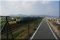
3
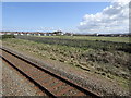
View from a Chester-Holyhead train - Empty field between caravan parks, Belgrano
Image: © Nigel Thompson
Taken: 2 May 2018
0.06 miles
4
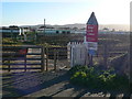
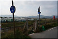
Stop Look Listen
A pedestrian crossing over the Chester to Holyhead railway line
Image: © Eirian Evans
Taken: 6 Dec 2008
0.07 miles
6
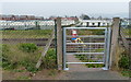
Level crossing across the North Wales Coast Line
Linking the Wales Coast Path and the Lyndale Holiday Park at Belgrano.
Image: © Mat Fascione
Taken: 16 Apr 2019
0.09 miles
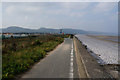
9
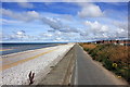
The Wales Coast Path at Pensarn
The Wales Coast Path heading east between Pensarn and Belgrano.
Image: © Jeff Buck
Taken: 24 Aug 2015
0.10 miles
10
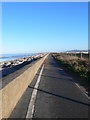
North Wales path
The North Wales Path winds for 60 miles along the coast from Bangor to Prestatyn, mostly along public footpaths. It takes you to traditional seaside resorts which you can reach from the path, and also gives you stunning mountain and coastal views. Here is the path near Belgrano, Abergele.
Image: © Eirian Evans
Taken: 6 Dec 2008
0.11 miles