IMAGES TAKEN NEAR TO
Pandy Tudur, ABERGELE, LL22 8UE
Introduction
This page details the photographs taken nearby to LL22 8UE by members of the Geograph project.
The Geograph project started in 2005 with the aim of publishing, organising and preserving representative images for every square kilometre of Great Britain, Ireland and the Isle of Man.

There are currently over 7.5m images from over14,400 individuals and you can help contribute to the project by visiting https://www.geograph.org.uk
Image Map
Images are licensed for reuse under creativecommons.org/licenses/by-sa/2.0
Notes
- Clicking on the map will re-center to the selected point.
- The higher the marker number, the further away the image location is from the centre of the postcode.
Image Listing (5 Images Found)
Images are licensed for reuse under creativecommons.org/licenses/by-sa/2.0
Image
Details
Distance
1
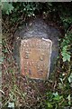
Old Milestone by the A548, north of The Old Vicarage, Llangernyw parish
Stone post with plate by the A548, in parish of Llangernyw (Conwy County Borough District), North of The Old Vicarage, 100m East of footpath junction, North side of road.
Inscription reads:-
LLANRWST
MILES FURLONGS
5 . 0
---.---
ABERGELE
MILES FURLONGS
11 . 6
To be surveyed
Milestone Society National ID: DEN_LRAG05
Image: © Milestone Society
Taken: Unknown
0.10 miles
2
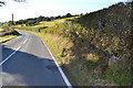
Llanrwst 5
Old milestone on the A.548 near to Pandy Tudur, Conwy. For close upview see http://www.geograph.org.uk/photo/5183792
Image: © Keith Evans
Taken: 9 Oct 2016
0.11 miles
3
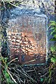
Old Milestone
Old milestone on the A.548 near to Pandy Tudur, Conwy. For overall view see http://www.geograph.org.uk/photo/5183795
Image: © Keith Evans
Taken: 9 Oct 2016
0.11 miles
4
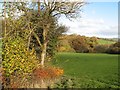
Afon Derfyn valley
Autumn tints in the Derfyn valley.
Image: © Jonathan Wilkins
Taken: 8 Nov 2019
0.19 miles
5
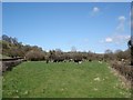
Grazing on Easter Sunday
Cattle grazing on farmland near Pandy Tudur
Image: © Dot Potter
Taken: 16 Apr 2006
0.24 miles