IMAGES TAKEN NEAR TO
Llangernyw, ABERGELE, LL22 8UB
Introduction
This page details the photographs taken nearby to LL22 8UB by members of the Geograph project.
The Geograph project started in 2005 with the aim of publishing, organising and preserving representative images for every square kilometre of Great Britain, Ireland and the Isle of Man.

There are currently over 7.5m images from over14,400 individuals and you can help contribute to the project by visiting https://www.geograph.org.uk
Image Map (Loading...)


Getting Data...Please wait
Leaflet Map data © OpenStreetMap
Images are licensed for reuse under creativecommons.org/licenses/by-sa/2.0
Notes
- Clicking on the map will re-center to the selected point.
- The higher the marker number, the further away the image location is from the centre of the postcode.
Image Listing (6 Images Found)
Images are licensed for reuse under creativecommons.org/licenses/by-sa/2.0
Image
Details
Distance
1
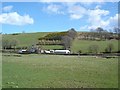
Hendre Ddu
Farm at Hendre Ddu near to Llangernyw
Image: © Dot Potter
Taken: 16 Apr 2006
0.09 miles
2
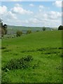
Grazing land, south of Rhan Hir Farm
About 185 metres above sea level.
Image: © Christine Johnstone
Taken: 2 May 2017
0.20 miles
3
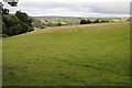
Farmland near Rhan Hir Farm
Farmland near Rhan Hir Farm near the village of Llangernyw.
Image: © Philip Halling
Taken: 16 Aug 2014
0.21 miles
4
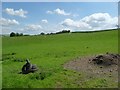
Sheep grazing south of Rhan Hir Farm
I think the tyres provide a 'stop' for an open field gate.
Image: © Christine Johnstone
Taken: 2 May 2017
0.22 miles

6
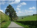
Tree outside Rhan Hir Farm
The road is descending steeply from a 187 metre spot height.
Image: © Christine Johnstone
Taken: 2 May 2017
0.25 miles