IMAGES TAKEN NEAR TO
Lon Deg, ABERGELE, LL22 8PZ
Introduction
This page details the photographs taken nearby to Lon Deg, LL22 8PZ by members of the Geograph project.
The Geograph project started in 2005 with the aim of publishing, organising and preserving representative images for every square kilometre of Great Britain, Ireland and the Isle of Man.

There are currently over 7.5m images from over14,400 individuals and you can help contribute to the project by visiting https://www.geograph.org.uk
Image Map (Loading...)


Getting Data...Please wait
Leaflet Map data © OpenStreetMap
Images are licensed for reuse under creativecommons.org/licenses/by-sa/2.0
Notes
- Clicking on the map will re-center to the selected point.
- The higher the marker number, the further away the image location is from the centre of the postcode.
Image Listing (8 Images Found)
Images are licensed for reuse under creativecommons.org/licenses/by-sa/2.0
Image
Details
Distance
1
Welcome to Abergele - Historic Market Town
Sign on Llanfair Road, entering Abergele from the south.
Image: © David Dixon
Taken: 21 Apr 2015
0.15 miles
4
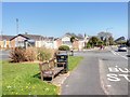
Seat by Llanfair Road, Abergele
Bus stop on Llanfair Road, outskirts of Abergele.
Image: © David Dixon
Taken: 21 Apr 2015
0.21 miles
5

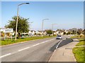
A548 path
Footpath alongside main road into Abergele.
Image: © J Scott
Taken: 9 Aug 2011
0.22 miles
6
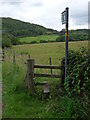
Abergele path
Footpath leading to Tower Hill.
Image: © J Scott
Taken: 9 Aug 2011
0.22 miles
7
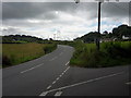
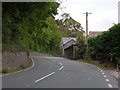
Twll-llwynog junction
The A548 from Abergele leading to Llanfair Talhaiarn.
Image: © J Scott
Taken: 9 Aug 2011
0.23 miles
8
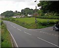
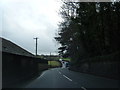
Twll-llwynog junction
Junction off the A548.
Image: © J Scott
Taken: 9 Aug 2011
0.23 miles