IMAGES TAKEN NEAR TO
Penrefail Crossroads, ABERGELE, LL22 8PN
Introduction
This page details the photographs taken nearby to Penrefail Crossroads, LL22 8PN by members of the Geograph project.
The Geograph project started in 2005 with the aim of publishing, organising and preserving representative images for every square kilometre of Great Britain, Ireland and the Isle of Man.

There are currently over 7.5m images from over14,400 individuals and you can help contribute to the project by visiting https://www.geograph.org.uk
Image Map (Loading...)


Getting Data...Please wait
Leaflet Map data © OpenStreetMap
Images are licensed for reuse under creativecommons.org/licenses/by-sa/2.0
Notes
- Clicking on the map will re-center to the selected point.
- The higher the marker number, the further away the image location is from the centre of the postcode.
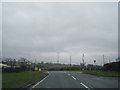
Image Listing (6 Images Found)
Images are licensed for reuse under creativecommons.org/licenses/by-sa/2.0
Image
Details
Distance
1
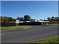
Caravan Home
Junction of the A548 and the B5381.
Image: © J Scott
Taken: 25 Oct 2010
0.09 miles
5
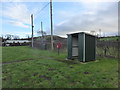
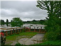
Bus shelter near the junction
There is a BT cabinet against the hedge, but no sign of the Public Telephone marked on the map.
Image: © David Medcalf
Taken: 5 Jan 2015
0.13 miles
6
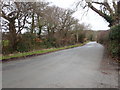
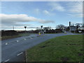
The B5381 near Penrefail Crossroads
The road straight on continues to Betws-yn-Rhos
Image: © Eirian Evans
Taken: 9 Mar 2020
0.20 miles