IMAGES TAKEN NEAR TO
Pentre Isa, ABERGELE, LL22 8PH
Introduction
This page details the photographs taken nearby to Pentre Isa, LL22 8PH by members of the Geograph project.
The Geograph project started in 2005 with the aim of publishing, organising and preserving representative images for every square kilometre of Great Britain, Ireland and the Isle of Man.

There are currently over 7.5m images from over14,400 individuals and you can help contribute to the project by visiting https://www.geograph.org.uk
Image Map (Loading...)


Getting Data...Please wait
Leaflet Map data © OpenStreetMap
Images are licensed for reuse under creativecommons.org/licenses/by-sa/2.0
Notes
- Clicking on the map will re-center to the selected point.
- The higher the marker number, the further away the image location is from the centre of the postcode.
Image Listing (6 Images Found)
Images are licensed for reuse under creativecommons.org/licenses/by-sa/2.0
Image
Details
Distance
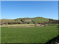
1
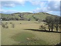
Hillside near Llangernyw
To the north of the village
Image: © Dot Potter
Taken: 25 Feb 2006
0.15 miles
3
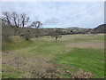
Fields and ancient river bank near Llangernyw
Afon Elwy lies across the field.
Image: © David Medcalf
Taken: 26 Jan 2015
0.18 miles
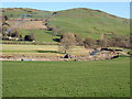
6
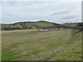
Fields next to Afon Elwy
There appears to have been significant dredging on the nearside bank of the river - or perhaps preparation for flood defences? The fence shown on the map, crossing the field in front of the camera, is no longer there. It appears that the road is built on top of the ancient river bank and the fields are the alluvial plain.
Image: © David Medcalf
Taken: 26 Jan 2015
0.24 miles