IMAGES TAKEN NEAR TO
Llanfair Road, ABERGELE, LL22 8PB
Introduction
This page details the photographs taken nearby to Llanfair Road, LL22 8PB by members of the Geograph project.
The Geograph project started in 2005 with the aim of publishing, organising and preserving representative images for every square kilometre of Great Britain, Ireland and the Isle of Man.

There are currently over 7.5m images from over14,400 individuals and you can help contribute to the project by visiting https://www.geograph.org.uk
Image Map (Loading...)


Getting Data...Please wait
Leaflet Map data © OpenStreetMap
Images are licensed for reuse under creativecommons.org/licenses/by-sa/2.0
Notes
- Clicking on the map will re-center to the selected point.
- The higher the marker number, the further away the image location is from the centre of the postcode.
Image Listing (3 Images Found)
Images are licensed for reuse under creativecommons.org/licenses/by-sa/2.0
Image
Details
Distance
2
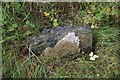
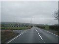
Old Milestone by the A548, Betws yn Rhos Parish, Conwy
By the A548, in parish of Betws yn Rhos (Conwy County Borough District), Ty Mawr, on verge. Badly damaged.
Inscription once read:-
: (Abergele / 1¾) : : (Llanrwst / 15) :
Grade II Listed by Cadw.
Reference Number 20109: https://cadwpublic-api.azurewebsites.net/reports/listedbuilding/FullReport?lang=&id=20109
To be surveyed
Milestone Society National ID: DEN_LRAG15
Image: © Milestone Society
Taken: Unknown
0.19 miles
3
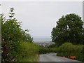
Looking out to sea from Sirior Bach
View from theA548 from Sirior Bach over Abergele to the North Wales Coast
Image: © Dot Potter
Taken: 14 Jul 2005
0.24 miles