IMAGES TAKEN NEAR TO
Dolwen, ABERGELE, LL22 8NL
Introduction
This page details the photographs taken nearby to LL22 8NL by members of the Geograph project.
The Geograph project started in 2005 with the aim of publishing, organising and preserving representative images for every square kilometre of Great Britain, Ireland and the Isle of Man.

There are currently over 7.5m images from over14,400 individuals and you can help contribute to the project by visiting https://www.geograph.org.uk
Image Map (Loading...)


Getting Data...Please wait
Leaflet Map data © OpenStreetMap
Images are licensed for reuse under creativecommons.org/licenses/by-sa/2.0
Notes
- Clicking on the map will re-center to the selected point.
- The higher the marker number, the further away the image location is from the centre of the postcode.
Image Listing (5 Images Found)
Images are licensed for reuse under creativecommons.org/licenses/by-sa/2.0
Image
Details
Distance
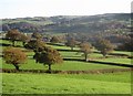
2

Green fields and blue skies
Fields near to Cefn Castell
Image: © Dot Potter
Taken: 20 Feb 2006
0.09 miles
4
Tir pori ger Ffernant / Grazing land near Ffernant
Image: © Ceri Thomas
Taken: 1 Nov 2017
0.16 miles
5
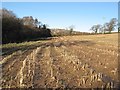
Maize crop residua
Interesting textures in maize stubble. Housing in the far distance is on the slope of Mynydd Marian Imagenear Llysfaen.
Image: © Jonathan Wilkins
Taken: 20 Jan 2016
0.21 miles