IMAGES TAKEN NEAR TO
Cwymp Road, ABERGELE, LL22 8NB
Introduction
This page details the photographs taken nearby to Cwymp Road, LL22 8NB by members of the Geograph project.
The Geograph project started in 2005 with the aim of publishing, organising and preserving representative images for every square kilometre of Great Britain, Ireland and the Isle of Man.

There are currently over 7.5m images from over14,400 individuals and you can help contribute to the project by visiting https://www.geograph.org.uk
Image Map (Loading...)


Getting Data...Please wait
Leaflet Map data © OpenStreetMap
Images are licensed for reuse under creativecommons.org/licenses/by-sa/2.0
Notes
- Clicking on the map will re-center to the selected point.
- The higher the marker number, the further away the image location is from the centre of the postcode.
Image Listing (11 Images Found)
Images are licensed for reuse under creativecommons.org/licenses/by-sa/2.0
Image
Details
Distance
1
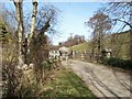
Bridge over Afon Dulas
This bridge now crosses the Afon Dulas on the unclassified road between Rhyd y Foel and Bryn Dulas. The name Rhyd y Foel implies that there was originally a ford here.
Image: © Jonathan Wilkins
Taken: 19 Mar 2008
0.05 miles
2
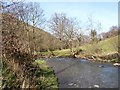
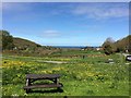
Afon Dulas
A view of the rather rapid river heading northwards through the gap in the coastal hills.
Image: © Jonathan Wilkins
Taken: 19 Mar 2008
0.06 miles
3
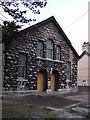
Salem methodist church
An austere but distinguished building in the village centre.
Image: © Jonathan Wilkins
Taken: 14 Mar 2008
0.13 miles
4
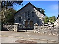
Salem Wesleyan Methodist Chapel, Rhyd-y-foel
The Salem Methodist Chapel was built in 1825, enlarged in 1831 and 1844 and renovated in 1868. The chapel was then rebuilt in 1894, to the design of architect Richard Davies of Bangor, in the Vernacular style with a gable entry plan.
Image: © Richard Hoare
Taken: 22 Apr 2017
0.14 miles
5
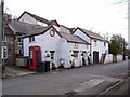
The old post-office
A picturesque cluster of roadside buildings, including a proper telephone box and the old post office.
Image: © Jonathan Wilkins
Taken: 14 Mar 2008
0.16 miles
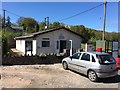
8
Event signage
A local resident has embarked on writing a book about the local men who went to war in 1914-18 and 1939-45.
She had organised a one day display in the local community centre at Rhyd-y-foel.
Image: © Richard Hoare
Taken: 22 Apr 2017
0.18 miles
9
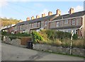
Tai teras yn Rhyd-y-Foel / Terraced housing at Rhyd-y-Foel
Image: © Ceri Thomas
Taken: 27 Nov 2011
0.20 miles
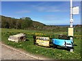
10
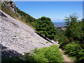
North Wales LDP
The path skirts the scree of limestone debris below Craig y Forwyn as it heads down to the coast.
Image: © Jonathan Wilkins
Taken: 13 Jun 2008
0.23 miles