IMAGES TAKEN NEAR TO
Llindir Road, ABERGELE, LL22 8LZ
Introduction
This page details the photographs taken nearby to Llindir Road, LL22 8LZ by members of the Geograph project.
The Geograph project started in 2005 with the aim of publishing, organising and preserving representative images for every square kilometre of Great Britain, Ireland and the Isle of Man.

There are currently over 7.5m images from over14,400 individuals and you can help contribute to the project by visiting https://www.geograph.org.uk
Image Map (Loading...)


Getting Data...Please wait
Leaflet Map data © OpenStreetMap
Images are licensed for reuse under creativecommons.org/licenses/by-sa/2.0
Notes
- Clicking on the map will re-center to the selected point.
- The higher the marker number, the further away the image location is from the centre of the postcode.
Image Listing (3 Images Found)
Images are licensed for reuse under creativecommons.org/licenses/by-sa/2.0
Image
Details
Distance
1
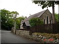
Converted chapel
Former chapel converted to houses at Bryn Dulas
Image: © Dot Potter
Taken: 23 Jul 2005
0.19 miles
2
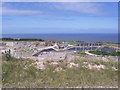
Llanddulas quarry
Originally this quarry exploited extremely pure beds of Carboniferous Limestone which was exported from the jetty to steelworks in Belgium. Extraction has now ceased, but the void is the primary destination of domestic and other waste for the Conwy County Borough. The black sheeting is an impermeable geomembrane to contain potential leachates and gases. Drainage is installed to produce a methane-rich gas which is burned at power plant just visible in the upper centre of the picture. Power from rubbish - bring it on!
Image: © Jonathan Wilkins
Taken: 13 Jun 2008
0.20 miles
3
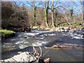
Afon Dulas
Leafless trees open up the view of the Afon Dulas in late Winter. Recent rain has increased the flow in this steep section where the river cuts through the steep limestone hills near to the coast.
Image: © Jonathan Wilkins
Taken: 17 Mar 2008
0.23 miles