IMAGES TAKEN NEAR TO
Abergele Road, ABERGELE, LL22 8HR
Introduction
This page details the photographs taken nearby to Abergele Road, LL22 8HR by members of the Geograph project.
The Geograph project started in 2005 with the aim of publishing, organising and preserving representative images for every square kilometre of Great Britain, Ireland and the Isle of Man.

There are currently over 7.5m images from over14,400 individuals and you can help contribute to the project by visiting https://www.geograph.org.uk
Image Map (Loading...)


Getting Data...Please wait
Leaflet Map data © OpenStreetMap
Images are licensed for reuse under creativecommons.org/licenses/by-sa/2.0
Notes
- Clicking on the map will re-center to the selected point.
- The higher the marker number, the further away the image location is from the centre of the postcode.
Image Listing (16 Images Found)
Images are licensed for reuse under creativecommons.org/licenses/by-sa/2.0
Image
Details
Distance
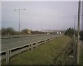
1
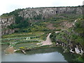
Llanddulas Quarry
Quarrying began in Llanddulas in 1696 and still continues today. There are three large limestone quarries between Llanddulas and Llysfaen.
Image: © Eirian Evans
Taken: 15 Aug 2007
0.08 miles
2
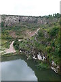
Llanddulas Quarry
Limestone quarry to the west of Llanddulas.
Image: © Eirian Evans
Taken: 15 Aug 2007
0.12 miles
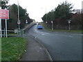
3
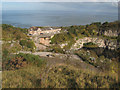
Quarry view
A view over the lower quarry which has been disused for many years. Prominent in the row of houses on Abergele Road is the Caersalem Congregational chapel. At this point the road has been widened to a dual carriageway by building a short viaduct over the edge of the workings.
Image: © Jonathan Wilkins
Taken: 19 Oct 2012
0.15 miles
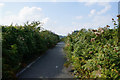
4
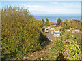
Quarry entrance road
A view of the junction between the public footpath and the quarry entrance road. It seems ironic that the quarry is busier than ever, but the lorries now take material into the quarry for tipping. Old Man's Beard and rose-hips make Autumn colour.
Image: © Jonathan Wilkins
Taken: 19 Oct 2012
0.17 miles
5
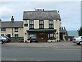
Dulas Arms
Situated on Abergele Road, Llanddulas.
Image: © Eirian Evans
Taken: 15 Aug 2007
0.18 miles
6
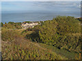
Footpath descent
A view of the public footpath which drops down the rib of solid ground between the lower two parts of the disused Llanddulas quarry, which is now operated as a landfill only. In the background is the sea with a corner of the wind turbine array.
Image: © Jonathan Wilkins
Taken: 19 Oct 2012
0.18 miles