IMAGES TAKEN NEAR TO
Wern Road, ABERGELE, LL22 8HG
Introduction
This page details the photographs taken nearby to Wern Road, LL22 8HG by members of the Geograph project.
The Geograph project started in 2005 with the aim of publishing, organising and preserving representative images for every square kilometre of Great Britain, Ireland and the Isle of Man.

There are currently over 7.5m images from over14,400 individuals and you can help contribute to the project by visiting https://www.geograph.org.uk
Image Map
Images are licensed for reuse under creativecommons.org/licenses/by-sa/2.0
Notes
- Clicking on the map will re-center to the selected point.
- The higher the marker number, the further away the image location is from the centre of the postcode.
Image Listing (75 Images Found)
Images are licensed for reuse under creativecommons.org/licenses/by-sa/2.0
Image
Details
Distance
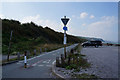
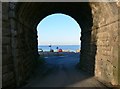
1
Wern Road, Llanddulas
Leading down to the beach.
Image: © Eirian Evans
Taken: 14 Jan 2012
0.02 miles
2
Beach at Llanddulas
Taken from the beach at high tide.
Image: © Dot Potter
Taken: 6 Aug 2005
0.02 miles
3
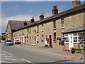
Cottages at Llanddulas
Stone cottages at Llanddulas
Image: © Dot Potter
Taken: 16 Jul 2005
0.02 miles
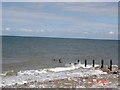
4
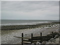
Llanddulas beach looking east
The beach at Llanddulas with groynes and other coastal protection measures. Looking East towards Rhyl.
Image: © Lizzie
Taken: 25 Jul 2004
0.02 miles
5
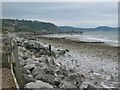
Llanddulas beach and quarry jetties
Coastal management measures and limestone quarry jetties looking west with Colwyn Bay in the background.
Image: © Lizzie
Taken: 25 Jul 2004
0.02 miles
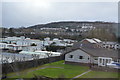
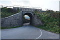
8
Approaching the beach at Llanddulas
Wern Road goes under the Railway bridge.
Image: © Eirian Evans
Taken: 14 Jan 2012
0.06 miles