IMAGES TAKEN NEAR TO
Abergele Road, ABERGELE, LL22 8EY
Introduction
This page details the photographs taken nearby to Abergele Road, LL22 8EY by members of the Geograph project.
The Geograph project started in 2005 with the aim of publishing, organising and preserving representative images for every square kilometre of Great Britain, Ireland and the Isle of Man.

There are currently over 7.5m images from over14,400 individuals and you can help contribute to the project by visiting https://www.geograph.org.uk
Image Map (Loading...)


Getting Data...Please wait
Leaflet Map data © OpenStreetMap
Images are licensed for reuse under creativecommons.org/licenses/by-sa/2.0
Notes
- Clicking on the map will re-center to the selected point.
- The higher the marker number, the further away the image location is from the centre of the postcode.
Image Listing (26 Images Found)
Images are licensed for reuse under creativecommons.org/licenses/by-sa/2.0
Image
Details
Distance
1
Tan yr Ogof Farm
Elaborately ornate farm buildings in the style of the victorian folly nearby Image The Dundonald estate adopted this particular architecture for all the buildings and walls within the estate.
Image: © Jonathan Wilkins
Taken: 17 Mar 2008
0.02 miles
2

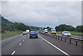
A547 Abergele Road at Rhyd-y-foel Road junction
Image: © Colin Pyle
Taken: 4 Apr 2011
0.06 miles
3
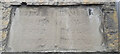
Old Guide Stone on Abergele Road, A547
The Guidestone is embedded in the wall at the side of the road, in parish of Betws yn Rhos (Conwy County Borough District), erected in the 18th century.
Inscription reads:-
ABERGELE / ST ASAPH / CHESTER / LONDON :: LLANDDULAS / CONWAY / BANGOR / CEMAES
Milestone Society National ID: DEN_XRHYD01
Image: © Debbie Williams
Taken: 14 May 2024
0.08 miles
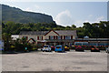
4
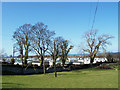
Caravans and trees
Caravans are an ever-present feature of this stretch of coast. This is the Tanrogo site, an anglicised version of the name given to the nearby farm, Tan yr Ogof (below the cave). Leafless trees make a beautiful structure in the Winter light.
Image: © Jonathan Wilkins
Taken: 17 Mar 2008
0.08 miles
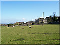
6
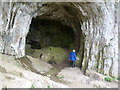
Cave, Cefn yr Ogof
The hill is named after this large cave
Image: © Michael Graham
Taken: 16 May 2013
0.12 miles
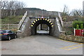
7
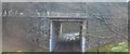
Railway bridge
Now dwarfed by the nearby A55 dual-carriageway, this original bridge has a symmetrical charm lacking in the other concrete box structure.
Image: © Jonathan Wilkins
Taken: 17 Mar 2008
0.14 miles
8
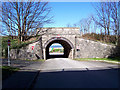
Railway bridge over Beach Road, Llandulas
Number 85 I believe.
Image: © Richard Hoare
Taken: 27 Jan 2018
0.14 miles