IMAGES TAKEN NEAR TO
Tan Y Gopa, ABERGELE, LL22 8DS
Introduction
This page details the photographs taken nearby to Tan Y Gopa, LL22 8DS by members of the Geograph project.
The Geograph project started in 2005 with the aim of publishing, organising and preserving representative images for every square kilometre of Great Britain, Ireland and the Isle of Man.

There are currently over 7.5m images from over14,400 individuals and you can help contribute to the project by visiting https://www.geograph.org.uk
Image Map (Loading...)


Getting Data...Please wait
Leaflet Map data © OpenStreetMap
Images are licensed for reuse under creativecommons.org/licenses/by-sa/2.0
Notes
- Clicking on the map will re-center to the selected point.
- The higher the marker number, the further away the image location is from the centre of the postcode.
Image Listing (9 Images Found)
Images are licensed for reuse under creativecommons.org/licenses/by-sa/2.0
Image
Details
Distance
2
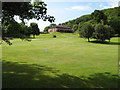
Golf course and club house
Across the green to the clubhouse of the Abergele Golf Club.
Image: © Jonathan Wilkins
Taken: 1 Jul 2008
0.12 miles
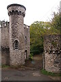
4
Nant y Bella
A modernised dwelling has been created in this gatehouse to Gwrych Castle, whose main feature is a tall, circular tower. Yet another folly in this bizarre, walled estate.
Image: © Jonathan Wilkins
Taken: 24 Jun 2008
0.21 miles
5
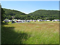
Camping field
Although there is a permanent caravan and camping site at the farm in the corner of the Gwrych Castle enclosure, this is a temporary site set up by the Caravan & Camping Club for the early summer. The wooded hillsides of the Carboniferous Limestone outcrop are very prominent in this view.
Image: © Jonathan Wilkins
Taken: 1 Jul 2008
0.21 miles
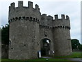
6
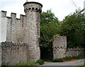
Gatehouse at Gwrych Castle
Gatehouse in the stone walls at Gwyrch Castle - on Tan y Gopa lane
Image: © Dot Potter
Taken: 23 Jul 2005
0.21 miles
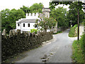
7
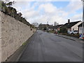
Tan-Y-Gopa Road
Tan-y-Gopa means Under the Summit. The road leads to a steep hill.
Image: © David Medcalf
Taken: 6 Jan 2015
0.22 miles
8
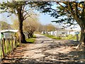
Path through Manorafon Farm Camping and Caravan Site
Part of the Gwrych Castle estate, behind Image] (the site was previously known as Gwrych Towers Campsite).
Image: © David Dixon
Taken: 21 Apr 2015
0.24 miles
9
Gateway to Gwrych Castle
Eastern entrance to the estate, in Abergele. Gwrych Castle was built in 1819 http://www.gwrychtrust.co.uk/html/brief_castle_history.html
Image: © Eirian Evans
Taken: 15 Aug 2007
0.24 miles