IMAGES TAKEN NEAR TO
Trofarth, ABERGELE, LL22 8BT
Introduction
This page details the photographs taken nearby to LL22 8BT by members of the Geograph project.
The Geograph project started in 2005 with the aim of publishing, organising and preserving representative images for every square kilometre of Great Britain, Ireland and the Isle of Man.

There are currently over 7.5m images from over14,400 individuals and you can help contribute to the project by visiting https://www.geograph.org.uk
Image Map (Loading...)


Getting Data...Please wait
Leaflet Map data © OpenStreetMap
Images are licensed for reuse under creativecommons.org/licenses/by-sa/2.0
Notes
- Clicking on the map will re-center to the selected point.
- The higher the marker number, the further away the image location is from the centre of the postcode.
Image Listing (2 Images Found)
Images are licensed for reuse under creativecommons.org/licenses/by-sa/2.0
Image
Details
Distance
1
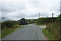
Dual footpaths near Penoros
Dual footpaths near Penoros North of Trofarth at SH 85506 72886.
Image: © Terry Hughes
Taken: 12 Aug 2006
0.11 miles
2
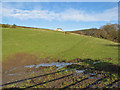
Chapel view
Looking up the pasture from the gate. The footpath crosses the stream here as it heads down to the bottom of the valley where there was once a bridge, but it is long gone. The view from the chapel must have been beautiful - but although still shown on the map, the chapel has now been replaced by a modern house.
Image: © Jonathan Wilkins
Taken: 27 Jan 2013
0.22 miles