IMAGES TAKEN NEAR TO
Troon Way, ABERGELE, LL22 7TT
Introduction
This page details the photographs taken nearby to Troon Way, LL22 7TT by members of the Geograph project.
The Geograph project started in 2005 with the aim of publishing, organising and preserving representative images for every square kilometre of Great Britain, Ireland and the Isle of Man.

There are currently over 7.5m images from over14,400 individuals and you can help contribute to the project by visiting https://www.geograph.org.uk
Image Map
Images are licensed for reuse under creativecommons.org/licenses/by-sa/2.0
Notes
- Clicking on the map will re-center to the selected point.
- The higher the marker number, the further away the image location is from the centre of the postcode.
Image Listing (21 Images Found)
Images are licensed for reuse under creativecommons.org/licenses/by-sa/2.0
Image
Details
Distance
1
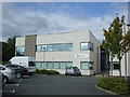
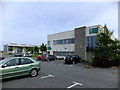
British Red Cross building North Wales Business Park
Inside a hive of activity including the loan of medical equipment to the locality.
Image: © Richard Hoare
Taken: 10 Aug 2011
0.12 miles
2
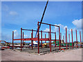
Kit construction
There is so little to a modern steel-framed building, that three men and a crane can throw it up in a matter of days. Expansion of the North Wales Business Park.
Image: © Jonathan Wilkins
Taken: 27 Feb 2008
0.13 miles
3
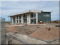
North Wales Business Park
Nearly complete externally after just six months. This is the companion building to that seen in image Image, which is also nearly ready for occupation.
Image: © Jonathan Wilkins
Taken: 22 Aug 2008
0.13 miles
4
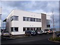
Building 5325
The North Wales Business Park has been in gestation for 25 years. The first phase of buildings have been in occupation since the Autumn of 2007. This unit is occupied by the UK subsidiary of an Australian company specialising in automated electron-microscopy for material analysis.
Image: © Jonathan Wilkins
Taken: 14 Jan 2008
0.14 miles
5
Spire Yale on North Wales Business Park
The consulting rooms for a private hospital.
Image: © Richard Hoare
Taken: 16 May 2014
0.14 miles
6
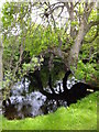
Tree in a pond
The tree had obviously fallen at some stage but had continued to grow giving this eerie image.
Image: © Richard Hoare
Taken: 16 May 2014
0.14 miles
7
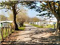
Path through Manorafon Farm Camping and Caravan Site
Part of the Gwrych Castle estate, behind Image] (the site was previously known as Gwrych Towers Campsite).
Image: © David Dixon
Taken: 21 Apr 2015
0.17 miles
9
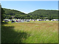
Camping field
Although there is a permanent caravan and camping site at the farm in the corner of the Gwrych Castle enclosure, this is a temporary site set up by the Caravan & Camping Club for the early summer. The wooded hillsides of the Carboniferous Limestone outcrop are very prominent in this view.
Image: © Jonathan Wilkins
Taken: 1 Jul 2008
0.18 miles
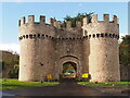
10
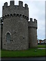
Gwrych Castle - gateway
Eastern entrance to the estate, in Abergele. Gwrych Castle was built in 1819
Image: © Eirian Evans
Taken: 15 Aug 2007
0.18 miles