IMAGES TAKEN NEAR TO
St. Davids Road, ABERGELE, LL22 7TP
Introduction
This page details the photographs taken nearby to St. Davids Road, LL22 7TP by members of the Geograph project.
The Geograph project started in 2005 with the aim of publishing, organising and preserving representative images for every square kilometre of Great Britain, Ireland and the Isle of Man.

There are currently over 7.5m images from over14,400 individuals and you can help contribute to the project by visiting https://www.geograph.org.uk
Image Map (Loading...)


Getting Data...Please wait
Leaflet Map data © OpenStreetMap
Images are licensed for reuse under creativecommons.org/licenses/by-sa/2.0
Notes
- Clicking on the map will re-center to the selected point.
- The higher the marker number, the further away the image location is from the centre of the postcode.
Image Listing (21 Images Found)
Images are licensed for reuse under creativecommons.org/licenses/by-sa/2.0
Image
Details
Distance
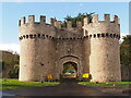
1
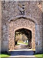
Through the Arch, King's Lodge
Image] is built of uncoursed limestone rubble, with squared dressings and slate roofs. Twin drum towers rise to a deep crenellated parapet in the manner of the Edwardian castles of North Wales. Between the towers, the outer gate has a 4-centred chamfered arch, and above, the family arms on a shield. Behind the towers, a small open court in a barbican leads to the inner gate set in a tall rear wall with a similar carriage arch.
Image: © David Dixon
Taken: 21 Apr 2015
0.19 miles
2
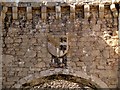
Family Crest over the Entrance Arch at King's Lodge
Image] is built of uncoursed limestone rubble, with squared dressings and slate roofs. Twin drum towers rise to a deep crenellated parapet in the manner of the Edwardian castles of North Wales. Between the towers, the outer gate has a 4-centred chamfered arch, and above, the family arms on a shield.
Image: © David Dixon
Taken: 21 Apr 2015
0.19 miles
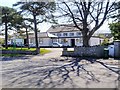
3
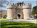
King's Lodge, Abergele
King’s Lodge, also known as Abergele Lodge is Located at the west end of the Abergele, at the junction of a lane to Tan-y-Gopa and Betws-yn-Rhos. It was built as a gateway to Gwrych Castle. The boundary wall, with its various lodges and gates probably followed the main building's completion ca1822, although works continued until ca1850.
The lodge is built of uncoursed limestone rubble, with squared dressings and slate roofs. Twin drum towers rise to a deep crenellated parapet in the manner of the Edwardian castles of North Wales. Between the towers, the outer gate has a 4-centred chamfered arch, and above, the family arms on a shield.
The lodge is grade II*-listed as “a conspicous landmark; an exemplar of the fashion for castellated structures of the time, and with important group value with the castle and other structures on the Gwrych Estate (Cadw Building ID: 233 http://www.britishlistedbuildings.co.uk/wa-233-king-s-lodge-also-known-as-abergele-lodge-a#.VTtwK2d0x_s British Listed Buildings).
Image: © David Dixon
Taken: 21 Apr 2015
0.19 miles
4
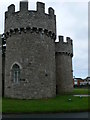
Gwrych Castle - gateway
Eastern entrance to the estate, in Abergele. Gwrych Castle was built in 1819
Image: © Eirian Evans
Taken: 15 Aug 2007
0.19 miles
6
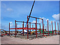
Kit construction
There is so little to a modern steel-framed building, that three men and a crane can throw it up in a matter of days. Expansion of the North Wales Business Park.
Image: © Jonathan Wilkins
Taken: 27 Feb 2008
0.19 miles
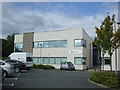
7
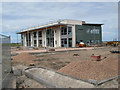
North Wales Business Park
Nearly complete externally after just six months. This is the companion building to that seen in image Image, which is also nearly ready for occupation.
Image: © Jonathan Wilkins
Taken: 22 Aug 2008
0.19 miles
8
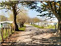
Path through Manorafon Farm Camping and Caravan Site
Part of the Gwrych Castle estate, behind Image] (the site was previously known as Gwrych Towers Campsite).
Image: © David Dixon
Taken: 21 Apr 2015
0.20 miles
9
British Red Cross building North Wales Business Park
Inside a hive of activity including the loan of medical equipment to the locality.
Image: © Richard Hoare
Taken: 10 Aug 2011
0.20 miles
10
Abergele Town Hall
The town hall and council offices set back from Llanddulas Road on the western side of Abergele.
Image: © David Dixon
Taken: 21 Apr 2015
0.21 miles