IMAGES TAKEN NEAR TO
Water Street, ABERGELE, LL22 7SN
Introduction
This page details the photographs taken nearby to Water Street, LL22 7SN by members of the Geograph project.
The Geograph project started in 2005 with the aim of publishing, organising and preserving representative images for every square kilometre of Great Britain, Ireland and the Isle of Man.

There are currently over 7.5m images from over14,400 individuals and you can help contribute to the project by visiting https://www.geograph.org.uk
Image Map (Loading...)


Getting Data...Please wait
Leaflet Map data © OpenStreetMap
Images are licensed for reuse under creativecommons.org/licenses/by-sa/2.0
Notes
- Clicking on the map will re-center to the selected point.
- The higher the marker number, the further away the image location is from the centre of the postcode.
Image Listing (88 Images Found)
Images are licensed for reuse under creativecommons.org/licenses/by-sa/2.0
Image
Details
Distance
1
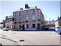
The Castle (Y Castell), Abergele
Wrapped around the corner between Dundonald Avenue and Pleasant Place, just to the north of the town centre, The Castle Hotel is one of Abergele’s prominent limestone buildings.
Probably built around the middle of the nineteenth century, it is grade II-listed (Cadw Building ID: 18698 http://www.britishlistedbuildings.co.uk/wa-18698-the-castle-y-castell-abergele#.VTuqZ2d0x_s British Listed Buildings) as “as a well-proportioned mid C19 urban building which has been little altered and of group value with Eglwys Crist Addoldy'r Annibynwyr”.
Image: © David Dixon
Taken: 21 Apr 2015
0.01 miles
2
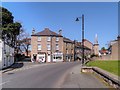
Abergele, Dundonald Avenue
Looking along Dundonald Avenue towards Pensarn.
Image: © David Dixon
Taken: 21 Apr 2015
0.01 miles
3
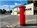
Post Box in Abergele
LL22 34. Royal Mail list this box as 'Groes Llwyd'.
Image: © David Bremner
Taken: 11 Jun 2022
0.01 miles
4
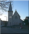
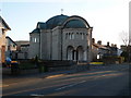
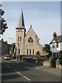
Eglwys Crist, Abergele
Congregational Church in Abergele. Originally opened in 1861 as an English church, but the Welsh chapel was later closed and this became a Welsh church.
Image: © Eirian Evans
Taken: 6 Dec 2008
0.02 miles
5
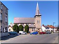
St Therese of Lisieux
Catholic church on the corner of Clwyd Avenue and Dundonald Avenue, Abergele
Image: © Eirian Evans
Taken: 6 Dec 2008
0.03 miles
6
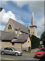
Eglwys Crist Addoldy'r Annibynnwyr
This former chapel, built 1860-61, is set on the corner of Dundonald Avenue and Pleasant Place, on the northern side of Abergele town centre.
It is a grade II listed building (CADW BUILDING ID: 18684 http://www.britishlistedbuildings.co.uk/wa-18684-eglwys-crist-addoldy-r-annibynnwyr-aberge#.VTusUGd0x_s British Listed Buildings).
Image: © David Dixon
Taken: 21 Apr 2015
0.03 miles
7
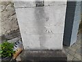
Ordnance Survey Cut Mark
This OS cut mark can be found on the east angle of the chapel on Dundonald Avenue. It marks a point 10.829m above mean sea level.
Image: © Adrian Dust
Taken: 28 Mar 2023
0.03 miles
8
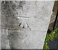
Ordnance Survey Cut Mark
This OS cut mark can be found on the South face of the Congregational Church. It marks a point 10.829m above mean sea level.
Image: © Adrian Dust
Taken: 19 Jun 2016
0.03 miles
9
Eglwys Crist, Addoldy'r Annibynwyr
A front view of this excellent Gothic building, facing onto Dundonald Avenue. History and details are given in the view of the rear and fine roof in image Image
I am indebted to Eric Jones for the advice that the name of the church was mis-spelled 'Annibynnwyr' on its name board, which I took as the correct form.
Image: © Jonathan Wilkins
Taken: 15 Aug 2008
0.04 miles
10
Christ Church
This new Congregational chapel was opened in 1861 as a consequence of differences between the English and Welsh adherents in the congregation. The architect was Roger Smith, a Londoner, and the result was a Gothic stone and timber construction which was embellished by the only spire in Abergele. Ultimately the original Congregational chapel was closed and the new one became Welsh-speaking. A front view can be found in image Image
Image: © Jonathan Wilkins
Taken: 14 Aug 2008
0.04 miles