IMAGES TAKEN NEAR TO
Queensway, ABERGELE, LL22 7RE
Introduction
This page details the photographs taken nearby to Queensway, LL22 7RE by members of the Geograph project.
The Geograph project started in 2005 with the aim of publishing, organising and preserving representative images for every square kilometre of Great Britain, Ireland and the Isle of Man.

There are currently over 7.5m images from over14,400 individuals and you can help contribute to the project by visiting https://www.geograph.org.uk
Image Map (157 Images)
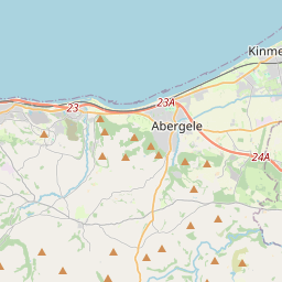


Leaflet Map data © OpenStreetMap
Images are licensed for reuse under creativecommons.org/licenses/by-sa/2.0
Notes
- Clicking on the map will re-center to the selected point.
- The higher the marker number, the further away the image location is from the centre of the postcode.
Image Listing (157 Images Found)
Images are licensed for reuse under creativecommons.org/licenses/by-sa/2.0
Image
Details
Distance
1
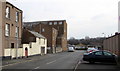
Kingsway, Pensarn, Abergele
From Marine Road to South Parade.
Image: © Jaggery
Taken: 27 Feb 2016
0.02 miles
2
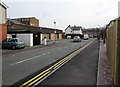
The Co-operative Food Store, Pensarn, Abergele
On the south side of Marine Road, between Queensway and Kingsway, viewed in February 2016.
A June 2011 Google Earth Street View shows Slaters Volkswagen car sales business on this site.
Image: © Jaggery
Taken: 27 Feb 2016
0.03 miles
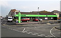
3
Coastal Carpets, Pensarn, Abergele
Carpet shop on the corner of the A548 and Queensway.
Image: © Jaggery
Taken: 27 Feb 2016
0.03 miles
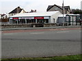
4
Meirion, Pensarn, Abergele
The street name Meirion extends for 80 metres from Marine Road to South Parade.
Image: © Jaggery
Taken: 27 Feb 2016
0.04 miles
5
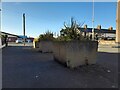
Concrete Planters, Pensarn
Attractive use of concrete at Meirion, Pensarn.
Image: © David Bremner
Taken: 18 Jul 2021
0.05 miles
6
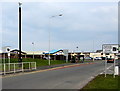
Speed cameras signs and a CCTV camera, Pensarn, Abergele
The signs are alongside the A548 Marine Road. A CCTV camera is on top of a tall pole.
Image: © Jaggery
Taken: 27 Feb 2016
0.05 miles
7
Distances from Pensarn, Abergele
The sign on a grass triangle facing eastbound traffic on the A548 shows Rhyl 5 (miles), Kinmel Bay 3, Towyn 1¾.
Image: © Jaggery
Taken: 27 Feb 2016
0.05 miles
8
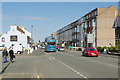
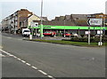
Marine Road, Pensarn
An Arriva bus heads away towards Rhyl past the Yacht (which was formerly known, perhaps more appropriately, as the Railway).
Image: © Stephen McKay
Taken: 4 Aug 2017
0.06 miles
9
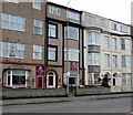
Gwesty Glyndwr, Pensarn, Abergele
Bed & breakfast accommodation, cafe and bistro at 18-20 Marine Road.
Image: © Jaggery
Taken: 27 Feb 2016
0.07 miles
10
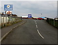
Beach and railway station direction sign, Pensarn
Turn left ahead for the beach (traeth in Welsh) and Abergele & Pensarn railway station.
The 20 tonnes weight limit shown 100 yards ahead is an error in February 2016 - it is only 18 tonnes. https://www.geograph.org.uk/photo/6379806
Image: © Jaggery
Taken: 27 Feb 2016
0.07 miles