IMAGES TAKEN NEAR TO
Tennis Court Road, ABERGELE, LL22 7RB
Introduction
This page details the photographs taken nearby to Tennis Court Road, LL22 7RB by members of the Geograph project.
The Geograph project started in 2005 with the aim of publishing, organising and preserving representative images for every square kilometre of Great Britain, Ireland and the Isle of Man.

There are currently over 7.5m images from over14,400 individuals and you can help contribute to the project by visiting https://www.geograph.org.uk
Image Map (Loading...)


Getting Data...Please wait
Leaflet Map data © OpenStreetMap
Images are licensed for reuse under creativecommons.org/licenses/by-sa/2.0
Notes
- Clicking on the map will re-center to the selected point.
- The higher the marker number, the further away the image location is from the centre of the postcode.
Image Listing (131 Images Found)
Images are licensed for reuse under creativecommons.org/licenses/by-sa/2.0
Image
Details
Distance
1
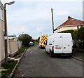
Tennis Court Road, Pensarn, Abergele
Short road on the north side of the A548. Beyond the vans and car, a path leads to a railway footbridge. http://www.geograph.org.uk/photo/4844559
Image: © Jaggery
Taken: 27 Feb 2016
0.01 miles
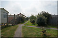
3
Daffodils, Pensarn, Abergele
On the left side of this path http://www.geograph.org.uk/photo/4844619 viewed on February 27th 2016. The text on the blue plaque is
"Supported by PeBel Residents Association". PeBel is short for Pensarn and Belgrano.
Image: © Jaggery
Taken: 27 Feb 2016
0.02 miles
4
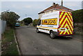
JTM Signs van, Tennis Court Road, Pensarn, Abergele
The traffic management and event signage highway maintenance van
is parked in Tennis Court Road, on the north side of the A548.
Image: © Jaggery
Taken: 27 Feb 2016
0.02 miles
6
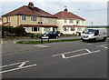
Towyn Road semis, Pensarn, Abergele
Semi-detached houses set back from the north side of the A548 Towyn Road.
Image: © Jaggery
Taken: 27 Feb 2016
0.03 miles
7
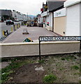
Tennis Court Road name sign, Pensarn, Abergele
When I saw this name sign, I wondered if this is the only Tennis Court Road in the UK.
It isn't. There is at least one other Tennis Court Road, in Cambridge. http://www.geograph.org.uk/photo/4838152
Costcutter http://www.geograph.org.uk/photo/4844534 is in the background.
Image: © Jaggery
Taken: 27 Feb 2016
0.03 miles
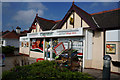
9
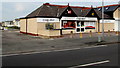
Costcutter, Pensarn, Abergele
Convenience store at 57 Marine Road.
Image: © Jaggery
Taken: 27 Feb 2016
0.03 miles
10
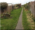
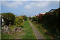
Path to a railway footbridge, Pensarn, Abergele
From the northern end of Tennis Court Road, the path leads to these http://www.geograph.org.uk/photo/4844559 footbridge steps,
partly visible behind a red bin in the background.
Image: © Jaggery
Taken: 27 Feb 2016
0.04 miles