IMAGES TAKEN NEAR TO
Pentre Mawr, ABERGELE, LL22 7PL
Introduction
This page details the photographs taken nearby to Pentre Mawr, LL22 7PL by members of the Geograph project.
The Geograph project started in 2005 with the aim of publishing, organising and preserving representative images for every square kilometre of Great Britain, Ireland and the Isle of Man.

There are currently over 7.5m images from over14,400 individuals and you can help contribute to the project by visiting https://www.geograph.org.uk
Image Map (Loading...)


Getting Data...Please wait
Leaflet Map data © OpenStreetMap
Images are licensed for reuse under creativecommons.org/licenses/by-sa/2.0
Notes
- Clicking on the map will re-center to the selected point.
- The higher the marker number, the further away the image location is from the centre of the postcode.
Image Listing (29 Images Found)
Images are licensed for reuse under creativecommons.org/licenses/by-sa/2.0
Image
Details
Distance
1
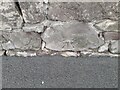
Ordnance Survey Cut Mark
This OS cut mark can be found on the wall NW side of Dundonald Avenue. It marks a point 7.583m above mean sea level.
Image: © Adrian Dust
Taken: 28 Mar 2023
0.08 miles
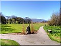
2

Rugby match in progress at Pentre Mawr Park, Abergele
Image: © Eirian Evans
Taken: 6 Dec 2008
0.09 miles
4
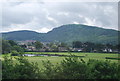
Pentre Mawr Park, Pensarn
Situated close to the beach, Pentre Mawr Park is a sizeable urban park in a largely residential area. Pentre Mawr Park used to be part of the Jones family estate who, through marriage, became the Jones-Bateman family living at Pentre Mawr for over 300 years. The grounds were acquired by the local authority in 1938.
Image: © David Dixon
Taken: 21 Apr 2015
0.15 miles
5
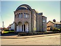
Eglwys Gatholic Santes Therese O Lisieux
The Catholic Church of St Theresa of Lisieux is a distinctive limestone building built in 1934. It is grade II-listed (Cadw Building ID: 18664 http://www.britishlistedbuildings.co.uk/wa-18664-church-of-st-teresa-of-lisieux-abergele#.VTuogmd0x_s British Listed Buildings) for its special interest as a prominently sited and distinctively Byzantine style inter-war church”.
Image: © David Dixon
Taken: 21 Apr 2015
0.19 miles
6
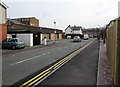
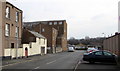
Kingsway, Pensarn, Abergele
From Marine Road to South Parade.
Image: © Jaggery
Taken: 27 Feb 2016
0.20 miles
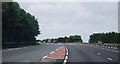
10
Meirion, Pensarn, Abergele
The street name Meirion extends for 80 metres from Marine Road to South Parade.
Image: © Jaggery
Taken: 27 Feb 2016
0.21 miles