IMAGES TAKEN NEAR TO
Berthglyd, ABERGELE, LL22 7HR
Introduction
This page details the photographs taken nearby to Berthglyd, LL22 7HR by members of the Geograph project.
The Geograph project started in 2005 with the aim of publishing, organising and preserving representative images for every square kilometre of Great Britain, Ireland and the Isle of Man.

There are currently over 7.5m images from over14,400 individuals and you can help contribute to the project by visiting https://www.geograph.org.uk
Image Map
Images are licensed for reuse under creativecommons.org/licenses/by-sa/2.0
Notes
- Clicking on the map will re-center to the selected point.
- The higher the marker number, the further away the image location is from the centre of the postcode.
Image Listing (20 Images Found)
Images are licensed for reuse under creativecommons.org/licenses/by-sa/2.0
Image
Details
Distance
1
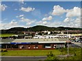
Faenol Avenue, Abergele
Threeways Garage, Faenol Avenue, Abergele, viewed from the A55.
Image: © Gerald England
Taken: 4 Jul 2008
0.04 miles
4
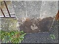
Ordnance Survey Cut Mark
This OS cut mark can be found on the old school, Bridge Street. It marks a point 16.540m above mean sea level.
Image: © Adrian Dust
Taken: 28 Mar 2023
0.14 miles
5
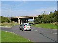
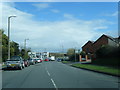
Threeways fly-over
The over-bridge on the north-western side of the Threeways roundabout, junction 24 on the A55. This point marked the eastern end of the Abergele By-pass dual-carriageway until the section from here to the foot of Rhuallt Hill was opened in the 1980's.
Image: © Jonathan Wilkins
Taken: 17 Sep 2008
0.15 miles
7
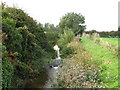
Weir, Afon Gele
After passing under the A55 Abergele by-pass, the river drops significantly to drain effectively the flat marshland of Morfa Gele. This weir protects the A55 from backwards erosion.
Image: © Jonathan Wilkins
Taken: 17 Sep 2008
0.18 miles
8
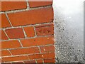
Ordnance Survey Cut Mark
This OS cut mark can be found on the NE parapet of the bridge on Faenol Avenue. It marks a point 11.236m above mean sea level.
Image: © Adrian Dust
Taken: 28 Mar 2023
0.18 miles
9
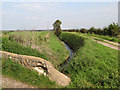
Bridge over Afon Gele
A rough bridge for the farm track over the deep cut of the Afon Gele. Here the river has descended into a cut protected by a high flood-bank. The track on the right bank is not the footpath, which is on the left, northern bank. The straight artificial cut and the flat land of the Morfa Gele indicate the serious issue of drainage here.
Image: © Jonathan Wilkins
Taken: 17 Sep 2008
0.19 miles
10
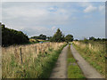
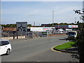
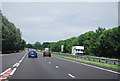
Slip road
A farm access track and footpath run against the flow of the eastbound off-ramp at the Threeways intersection of the A55. This is the end of the Abergele By-pass, the first dual-carriageway on the coast road.
Image: © Jonathan Wilkins
Taken: 17 Sep 2008
0.19 miles