IMAGES TAKEN NEAR TO
Cerrigydrudion, CORWEN, LL21 9TE
Introduction
This page details the photographs taken nearby to LL21 9TE by members of the Geograph project.
The Geograph project started in 2005 with the aim of publishing, organising and preserving representative images for every square kilometre of Great Britain, Ireland and the Isle of Man.

There are currently over 7.5m images from over14,400 individuals and you can help contribute to the project by visiting https://www.geograph.org.uk
Image Map
Images are licensed for reuse under creativecommons.org/licenses/by-sa/2.0
Notes
- Clicking on the map will re-center to the selected point.
- The higher the marker number, the further away the image location is from the centre of the postcode.
Image Listing (7 Images Found)
Images are licensed for reuse under creativecommons.org/licenses/by-sa/2.0
Image
Details
Distance
1
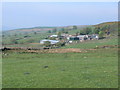
Ty'n-y-Gilfach
In the Hiraethog Hills, near Cefn-brith
Image: © Eirian Evans
Taken: 5 May 2007
0.05 miles
2
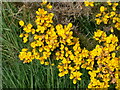
Gorse
The gorse was in full bloom as I went on my walk today, smelling slightly of coconut and reminding me of summer.
Image: © Eirian Evans
Taken: 5 May 2007
0.10 miles
3
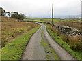
Minor road between stone wall and open land near Parc-newydd
Looking south-eastward.
Image: © Peter Wood
Taken: 20 Nov 2018
0.15 miles
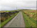
4
Minor road near Parc-newydd
Looking south-eastward.
Image: © Peter Wood
Taken: 20 Nov 2018
0.16 miles
5
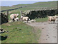
Sheep near Mynydd Poeth
In the Hiraethog Hills.
Image: © Eirian Evans
Taken: 5 May 2007
0.16 miles
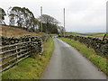
6
Minor road between stone wall and open ground near Parc-newydd
Looking north-westward.
Image: © Peter Wood
Taken: 20 Nov 2018
0.17 miles
7
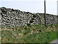
Dry Stone Wall near Cefn-Brith
This area of Hiraethog has many dry stone walls, and most in excellent condition. Here we can see how to climb over without a stile - large flat stones protruding either side to make steps over.
Image: © Eirian Evans
Taken: 5 May 2007
0.22 miles