IMAGES TAKEN NEAR TO
CORWEN, LL21 9RS
Introduction
This page details the photographs taken nearby to LL21 9RS by members of the Geograph project.
The Geograph project started in 2005 with the aim of publishing, organising and preserving representative images for every square kilometre of Great Britain, Ireland and the Isle of Man.

There are currently over 7.5m images from over14,400 individuals and you can help contribute to the project by visiting https://www.geograph.org.uk
Image Map
Images are licensed for reuse under creativecommons.org/licenses/by-sa/2.0
Notes
- Clicking on the map will re-center to the selected point.
- The higher the marker number, the further away the image location is from the centre of the postcode.
Image Listing (9 Images Found)
Images are licensed for reuse under creativecommons.org/licenses/by-sa/2.0
Image
Details
Distance
2
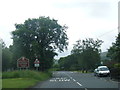
Junction of the A5104 and A494 at Clawdd Poncen
Image: © Eirian Evans
Taken: 23 Feb 2010
0.13 miles
3
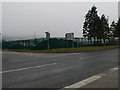
Industrial Estate, Corwen
Large factory at the Corwen Industrial Estate, Clawdd Poncen, to the north of Corwen.
Image: © Eirian Evans
Taken: 15 May 2006
0.13 miles
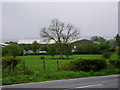
5

Ty'n y Gottel
Built at the side of the railway (now dismantled) at Clawdd Poncen, it is now overshadowed by Corwen's industrial estate.
Image: © Eirian Evans
Taken: 23 Feb 2010
0.17 miles
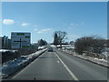
6
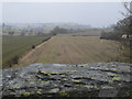
Looking north from the old railway bridge at Clawdd Poncen
The site of the old railway is obliterated. The trains ran from Ruthin to Corwen.
Image: © Eirian Evans
Taken: 23 Feb 2010
0.20 miles
7
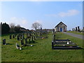
Corwen Cemetery
To the north of the town.
Image: © Eirian Evans
Taken: 24 Mar 2007
0.21 miles
8
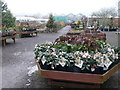
Hardy plants at Glyndwr Plant Centre, near Corwen
Image: © Eirian Evans
Taken: 23 Feb 2010
0.24 miles
9
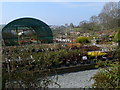
Glyndwr Plant Centre
Just off the Chester to Corwen road
Image: © Eirian Evans
Taken: 14 Apr 2007
0.25 miles