IMAGES TAKEN NEAR TO
Bryneglwys, CORWEN, LL21 9NN
Introduction
This page details the photographs taken nearby to LL21 9NN by members of the Geograph project.
The Geograph project started in 2005 with the aim of publishing, organising and preserving representative images for every square kilometre of Great Britain, Ireland and the Isle of Man.

There are currently over 7.5m images from over14,400 individuals and you can help contribute to the project by visiting https://www.geograph.org.uk
Image Map
Images are licensed for reuse under creativecommons.org/licenses/by-sa/2.0
Notes
- Clicking on the map will re-center to the selected point.
- The higher the marker number, the further away the image location is from the centre of the postcode.
Image Listing (10 Images Found)
Images are licensed for reuse under creativecommons.org/licenses/by-sa/2.0
Image
Details
Distance
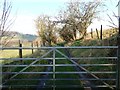
2
Track to Ty-cerrig
Viewed from the minor road that links the A542 and the A5104 roads.
Image: © John S Turner
Taken: 2 Mar 2007
0.14 miles
3
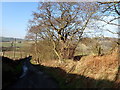
Steep hill with ancient hedgerow
The road descends to the A5104
Image: © Eirian Evans
Taken: 7 Feb 2020
0.18 miles
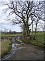
4
Minor Road Corner near Ty-cerrig
The corners on these steep narrow lanes require great care when driving. According to the map there is a footpath leading from the corner on the right, but there is no sign of it on the ground, or a stile to access the field.
Image: © John S Turner
Taken: 2 Mar 2007
0.18 miles
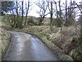
5
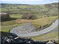
Hairpin Bend below Llantysilio Mountain
On this minor road a series of tight and narrow bends around these old quarry spoil heaps requires great care to negotiate safely. The road is the same shape on the 1879 map so the quarry works must be even older than that.
Image: © John S Turner
Taken: 3 Mar 2007
0.19 miles
6
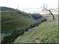
Deep gully running north from Plas Norway
Image: © Eirian Evans
Taken: 7 Feb 2020
0.20 miles
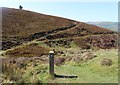
7
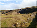
Former slate quarry on Llantysilio Mountain
Image: © Eirian Evans
Taken: 7 Feb 2020
0.21 miles
10
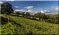
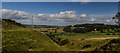
Plas-yn-Rhos
Fields above Plas-yn-Rhos.
Image: © Peter McDermott
Taken: 11 Sep 2016
0.25 miles