IMAGES TAKEN NEAR TO
Bryneglwys, CORWEN, LL21 9NA
Introduction
This page details the photographs taken nearby to LL21 9NA by members of the Geograph project.
The Geograph project started in 2005 with the aim of publishing, organising and preserving representative images for every square kilometre of Great Britain, Ireland and the Isle of Man.

There are currently over 7.5m images from over14,400 individuals and you can help contribute to the project by visiting https://www.geograph.org.uk
Image Map
Images are licensed for reuse under creativecommons.org/licenses/by-sa/2.0
Notes
- Clicking on the map will re-center to the selected point.
- The higher the marker number, the further away the image location is from the centre of the postcode.
Image Listing (7 Images Found)
Images are licensed for reuse under creativecommons.org/licenses/by-sa/2.0
Image
Details
Distance
1
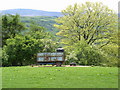
Slurry trailer
Trailer for muck-spreading on the fields
Image: © Eirian Evans
Taken: 4 Jun 2005
0.18 miles
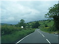
5
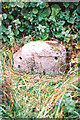
Old Milestone by the A5104, west of Bryneglwys
Milestone by the A5104, in parish of Bryneglwys (Denbighshire District), South of Pentre.
Inscription once read:-
(Corwen)
(6)
(Wrexham)
(15)
Surveyed
Milestone Society National ID: DEN_WRCN13
Image: © Milestone Society
Taken: Unknown
0.22 miles
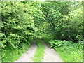
7
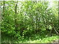
Coppice Hedge
This hazel hedge shows evidence of coppicing in the past
Image: © Eirian Evans
Taken: 4 Jun 2005
0.22 miles