IMAGES TAKEN NEAR TO
Carrog, CORWEN, LL21 9LD
Introduction
This page details the photographs taken nearby to LL21 9LD by members of the Geograph project.
The Geograph project started in 2005 with the aim of publishing, organising and preserving representative images for every square kilometre of Great Britain, Ireland and the Isle of Man.

There are currently over 7.5m images from over14,400 individuals and you can help contribute to the project by visiting https://www.geograph.org.uk
Image Map
Images are licensed for reuse under creativecommons.org/licenses/by-sa/2.0
Notes
- Clicking on the map will re-center to the selected point.
- The higher the marker number, the further away the image location is from the centre of the postcode.
Image Listing (4 Images Found)
Images are licensed for reuse under creativecommons.org/licenses/by-sa/2.0
Image
Details
Distance
1
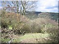
Stream and Hedges at Morfydd
Viewed from the minor road between Bryneglwys and Carrog, the stream is flowing towards the Afon Morwynion in the bottom of the valley.
Image: © John S Turner
Taken: 6 Mar 2007
0.15 miles
2
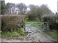
Trackway at Morfydd
This old track links the minor road through Morfydd to the Clwydian Way on the side of Llantysilio Mountain. Although the stream seems to be flowing down the track, the real stream is behind the high bank on the left of the track.
Image: © John S Turner
Taken: 6 Mar 2007
0.16 miles
3
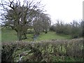
Stream and hedges at Morfydd
The small stream flows under the road and down to join the Afon Morwynion in the valley.
Image: © John S Turner
Taken: 6 Mar 2007
0.17 miles
4
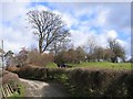
Old and New Roads at Morfydd
According to the 1891 O.S. map, and also indicated on the modern 25,000 scale map, the road used to go straight on here. This seems to be supported by the gate hidden in the hedge and the apparent kink in the hedge line. The modern road curves around a small quarry, hidden behind the trees and prominent hedge, which may have been the reason for the changes.
Image: © John S Turner
Taken: 6 Mar 2007
0.18 miles