IMAGES TAKEN NEAR TO
Gwyddelwern, CORWEN, LL21 9DE
Introduction
This page details the photographs taken nearby to LL21 9DE by members of the Geograph project.
The Geograph project started in 2005 with the aim of publishing, organising and preserving representative images for every square kilometre of Great Britain, Ireland and the Isle of Man.

There are currently over 7.5m images from over14,400 individuals and you can help contribute to the project by visiting https://www.geograph.org.uk
Image Map
Images are licensed for reuse under creativecommons.org/licenses/by-sa/2.0
Notes
- Clicking on the map will re-center to the selected point.
- The higher the marker number, the further away the image location is from the centre of the postcode.
Image Listing (5 Images Found)
Images are licensed for reuse under creativecommons.org/licenses/by-sa/2.0
Image
Details
Distance
1
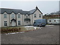
New houses at Gwyddelwern
A row of new houses at the southern end of the village
Image: © Eirian Evans
Taken: 23 Feb 2010
0.02 miles
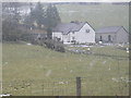
4
Ty Nant, Gwyddelwern
Ty Nant is a smallholding just on the southern outskirts of Gwyddelwern
Image: © Eirian Evans
Taken: 23 Feb 2010
0.06 miles
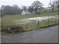
5
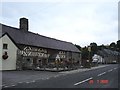
Ty Mawr at Gwyddelwern
Ty Mawr ( Big House) is reputedly the oldest inn in Wales - with village cottages also shown
Image: © Dot Potter
Taken: 29 Jul 2005
0.23 miles