IMAGES TAKEN NEAR TO
Glyndyfrdwy, CORWEN, LL21 9BS
Introduction
This page details the photographs taken nearby to LL21 9BS by members of the Geograph project.
The Geograph project started in 2005 with the aim of publishing, organising and preserving representative images for every square kilometre of Great Britain, Ireland and the Isle of Man.

There are currently over 7.5m images from over14,400 individuals and you can help contribute to the project by visiting https://www.geograph.org.uk
Image Map
Images are licensed for reuse under creativecommons.org/licenses/by-sa/2.0
Notes
- Clicking on the map will re-center to the selected point.
- The higher the marker number, the further away the image location is from the centre of the postcode.
Image Listing (7 Images Found)
Images are licensed for reuse under creativecommons.org/licenses/by-sa/2.0
Image
Details
Distance
1
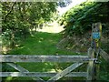
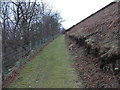
Upland path
Grassy pathway into the hills.
Image: © Jeremy Bolwell
Taken: 1 Aug 2024
0.15 miles
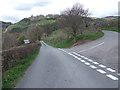
2
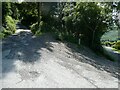
Lane junction
After a pleasing downhill section of walking I have to switch-back and set myself at an uphill section.
Image: © Jeremy Bolwell
Taken: 1 Aug 2024
0.16 miles
3
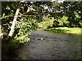
Afon Dyfrdwy at Garth y dwr
Deep in the valley, the river at its best.
Image: © John Haynes
Taken: 18 Sep 2005
0.19 miles
4
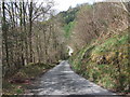
A sudden steep rise
The lane has been close to the river for some time but suddenly it moves away and upward.
Image: © John Haynes
Taken: 23 Apr 2012
0.22 miles
5
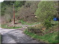
A place in the woods
This established forest has been sold off in small lots and people have begun to set up some tented weekend retreats.
Image: © John Haynes
Taken: 23 Apr 2012
0.23 miles
6
The lane to Wern-ddu
This lane becomes Llwybr Dyffryn Dyfrdwy (The Dee Valley Way) after 350m and when it reaches Wern-ddu it gets more like a track and eventually blends into a footpath.
http://www.llwybraudyffryndyfrdwy.com/thedeeveeway.htm
Image: © John Haynes
Taken: 23 Apr 2012
0.23 miles
7
The footpath towards Cymmo
This part of Llwybr Dyffryn Dyfrdwy (The Dee Valley Way) is cut into a steep slope with forest to the left and bracken to the right. You don't see many people here as you can cut off about 1Km of the route by heading straight across the top of a "V" in the walk.
http://www.llwybraudyffryndyfrdwy.com/thedeeveeway.htm
Image: © John Haynes
Taken: 23 Feb 2012
0.24 miles