IMAGES TAKEN NEAR TO
Ty Nant, CORWEN, LL21 0RH
Introduction
This page details the photographs taken nearby to LL21 0RH by members of the Geograph project.
The Geograph project started in 2005 with the aim of publishing, organising and preserving representative images for every square kilometre of Great Britain, Ireland and the Isle of Man.

There are currently over 7.5m images from over14,400 individuals and you can help contribute to the project by visiting https://www.geograph.org.uk
Image Map (Loading...)


Getting Data...Please wait
Leaflet Map data © OpenStreetMap
Images are licensed for reuse under creativecommons.org/licenses/by-sa/2.0
Notes
- Clicking on the map will re-center to the selected point.
- The higher the marker number, the further away the image location is from the centre of the postcode.
Image Listing (5 Images Found)
Images are licensed for reuse under creativecommons.org/licenses/by-sa/2.0
Image
Details
Distance

2
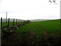
Llwybr. Path
Llwybr, yn wir trac i gyfeiriad yr A5.
This path is more of a track, looking towards the A5.
Image: © Alwyn Williams
Taken: 23 Apr 2007
0.10 miles
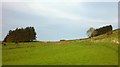
3
Farmland near Park
In the corner of the square.
Image: © David Medcalf
Taken: 4 Jun 2006
0.14 miles
4
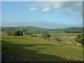
Fields SW of Ffynnon Wen
Early morning light picks out fenceposts and last years grasses as this year's spring growth gets under way.
Image: © Andy Waddington
Taken: 1 May 2011
0.20 miles
5
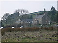
Canolfan Ffynnon Wen
Canolfan Ffynnon Wen is a residential Centre located near the Snowdonia National Park in the heart of North Wales, providing arts and environmental activities for children and young people. It was formerly a Youth Hostel.
Image: © Eirian Evans
Taken: 3 Apr 2009
0.23 miles