IMAGES TAKEN NEAR TO
Horseshoe Pass View, Brook Street, LLANGOLLEN, LL20 8LU
Introduction
This page details the photographs taken nearby to Horseshoe Pass View, Brook Street, LL20 8LU by members of the Geograph project.
The Geograph project started in 2005 with the aim of publishing, organising and preserving representative images for every square kilometre of Great Britain, Ireland and the Isle of Man.

There are currently over 7.5m images from over14,400 individuals and you can help contribute to the project by visiting https://www.geograph.org.uk
Image Map (Loading...)


Getting Data...Please wait
Leaflet Map data © OpenStreetMap
Images are licensed for reuse under creativecommons.org/licenses/by-sa/2.0
Notes
- Clicking on the map will re-center to the selected point.
- The higher the marker number, the further away the image location is from the centre of the postcode.
Image Listing (141 Images Found)
Images are licensed for reuse under creativecommons.org/licenses/by-sa/2.0
Image
Details
Distance
1
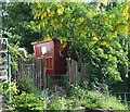
Springtime in the garden
This cottage garden is on a steep bank but it has been developed to utilise the space to maximum effect. There are two excellent carved wooden gateposts, and roof supports on the miniature caravan.
Image: © John Haynes
Taken: 9 Jun 2013
0.04 miles
2
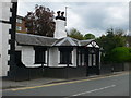
Old Tollgate House, Llangollen
Grade II listed building, on the A5, the main London to Holyhead road.
Image: © Eirian Evans
Taken: 16 Apr 2011
0.04 miles
3
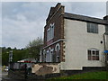
British Schools building, Llangollen
The British Schools were established in the mid-19th century to provide non-denominational education; a number of these schools were established in Wales by the Cambrian Educational Society. This one is on Brook Street, Llangollen, and is now the Penllyn Christian Centre.
Image: © Eirian Evans
Taken: 16 Apr 2011
0.05 miles
4
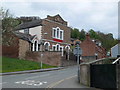
The old British School, Llangollen
This is now the Penllyn Christian Centre.
Image: © Eirian Evans
Taken: 16 Apr 2011
0.05 miles
5
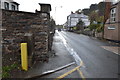
Old Milestone
Old milestone behind the yellow post on the A.5 at Llangollen, Denbighshire. For close up view see http://www.geograph.org.uk/photo/4244963
Image: © Keith Evans
Taken: 11 Oct 2014
0.05 miles
6
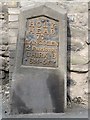
Old Milestone by the A5, Queen Street, Llangollen
Telford Plate by the A5, in parish of Llangollen (Denbighshire District), Llangollen just East of traffic lights in Queen Street, North side of road. Subsequently re-located in 2014 just around the corner in a more protected position.
Inscription reads:-
HOLY-
HEAD
77
LLANGOLLEN
2 Furlongs
CHIRK-B
6M-5F
Surveyed
Milestone Society National ID: DEN_HH77
Image: © Milestone Society
Taken: Unknown
0.06 miles
7
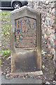
Old Milestone
Old milestone on the A.5 at Llangollen, Denbighshire. For overall view see http://www.geograph.org.uk/photo/4244964
Image: © Keith Evans
Taken: 11 Oct 2014
0.06 miles
8
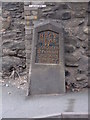
A Telford milestone (Holyhead 77), Llangollen
This is one of Thomas Telford's milestones located along the original London - Holyhead Road (A5). This one indicates that Holyhead is 77 miles away.
Image: © Meirion
Taken: 11 Jul 2011
0.06 miles
9
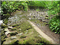
Plas Newydd - lower weir
A small artificial weir on the Cyflymen stream.
Image: © Stephen Craven
Taken: 24 May 2017
0.07 miles
