IMAGES TAKEN NEAR TO
Maes Collen, LLANGOLLEN, LL20 8EN
Introduction
This page details the photographs taken nearby to Maes Collen, LL20 8EN by members of the Geograph project.
The Geograph project started in 2005 with the aim of publishing, organising and preserving representative images for every square kilometre of Great Britain, Ireland and the Isle of Man.

There are currently over 7.5m images from over14,400 individuals and you can help contribute to the project by visiting https://www.geograph.org.uk
Image Map (Loading...)


Getting Data...Please wait
Leaflet Map data © OpenStreetMap
Images are licensed for reuse under creativecommons.org/licenses/by-sa/2.0
Notes
- Clicking on the map will re-center to the selected point.
- The higher the marker number, the further away the image location is from the centre of the postcode.
Image Listing (171 Images Found)
Images are licensed for reuse under creativecommons.org/licenses/by-sa/2.0
Image
Details
Distance
3
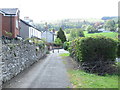
Grange Road, Llangollen
Heading out of town.
Image: © Stephen Craven
Taken: 21 May 2017
0.04 miles
5
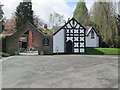
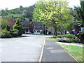
Former Stables - Plas Newydd
New used as ticket office & cafe
Image: © Betty Longbottom
Taken: 10 May 2013
0.08 miles
6
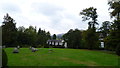
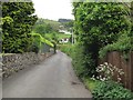
View from Plas Newydd, Llangollen to Castell Dinas Bran
The castle looks down on Plas Newydd.
Image: © Jeremy Bolwell
Taken: 14 Sep 2014
0.09 miles
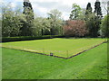

9
Plas Newydd in Llangollen
Stone circle visible left of centre
Image: © Chris Gunns
Taken: 16 Mar 2018
0.09 miles
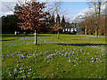
10
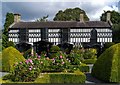
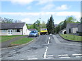
Plas Newydd, Llangollen
An image of the house showing its striking frontage and pretty rose beds and shrubs
Image: © Roger May
Taken: 19 Sep 2012
0.10 miles