IMAGES TAKEN NEAR TO
Abbey Road, LLANGOLLEN, LL20 8EF
Introduction
This page details the photographs taken nearby to Abbey Road, LL20 8EF by members of the Geograph project.
The Geograph project started in 2005 with the aim of publishing, organising and preserving representative images for every square kilometre of Great Britain, Ireland and the Isle of Man.

There are currently over 7.5m images from over14,400 individuals and you can help contribute to the project by visiting https://www.geograph.org.uk
Image Map (Loading...)


Getting Data...Please wait
Leaflet Map data © OpenStreetMap
Images are licensed for reuse under creativecommons.org/licenses/by-sa/2.0
Notes
- Clicking on the map will re-center to the selected point.
- The higher the marker number, the further away the image location is from the centre of the postcode.
Image Listing (65 Images Found)
Images are licensed for reuse under creativecommons.org/licenses/by-sa/2.0
Image
Details
Distance
1
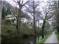
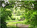
Llangollen Canal
Houses in background are in Abbey Road
Image: © PAUL FARMER
Taken: 6 Apr 2009
0.02 miles
2
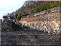
Building site, Llangollen
A hotel has been demolished here to make way for blocks of flats. Lately many blocks of flats have been built in Llangollen.
Image: © Eirian Evans
Taken: 18 Mar 2007
0.04 miles
3
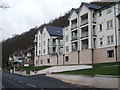
Recently built flats
Modern wooden framed multi-storey flats, built to replace some Edwardian houses similar to those further along Abbey Road. The ground floor is car parking & servicing. Image]
Image: © John Haynes
Taken: 15 Feb 2012
0.06 miles
4
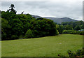
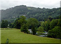
Riverside pasture and woodland near Llangollen, Denbighshire
The River Dee is between the pasture and the woodland. By the green shed on the right, the railway line crosses the river.
Image: © Roger D Kidd
Taken: 20 Sep 2015
0.06 miles
5

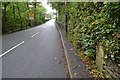
Llangollen Canal
The footpath between the town and the end of the canal is very well used. Canoeists also use the canal here to get to the river Dee at the Horseshoe Falls so that they can come down the "rapids".
Image: © Eirian Evans
Taken: 10 Apr 2011
0.07 miles
6
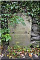
Old Milestone
Old Milestone on the A539 near to Berwy, Denbighshire. For overall view see http://www.geograph.org.uk/photo/5579820
Image: © Keith Evans
Taken: 23 Sep 2017
0.07 miles
7
Riverside pasture north-west of Llangollen, Denbighshire
This is a view from a passing railway train, showing the River Dee and the part wooded western slopes of the valley.
Image: © Roger D Kidd
Taken: 20 Sep 2015
0.08 miles
8
Signal for the sidings
This lower quadrant semaphore signal on the Llangollen Railway protects the exit from the carriage sidings ahead Image
Image: © Stephen Craven
Taken: 21 May 2017
0.08 miles
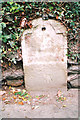
9
Old Milestone
Old mile next to the A539 near to Berwyn, Denbighshire. For close up view see http://www.geograph.org.uk/photo/5579815
Image: © Keith Evans
Taken: 23 Sep 2017
0.08 miles
10
Old Milestone by the A542, Llwyn Twr, Llangollen Parish
By the A542, in parish of Llangollen (Denbighshire District), Llwyn Twr, North of houses, East side of road.
Inscription once read:- : (Ruthin 12 / Llangollen 1) :
Carved bench mark on lower face.
Surveyed
Milestone Society National ID: DEN_LGRU12
Image: © Milestone Society
Taken: Unknown
0.08 miles