IMAGES TAKEN NEAR TO
LLANGOLLEN, LL20 8AW
Introduction
This page details the photographs taken nearby to LL20 8AW by members of the Geograph project.
The Geograph project started in 2005 with the aim of publishing, organising and preserving representative images for every square kilometre of Great Britain, Ireland and the Isle of Man.

There are currently over 7.5m images from over14,400 individuals and you can help contribute to the project by visiting https://www.geograph.org.uk
Image Map (Loading...)


Getting Data...Please wait
Leaflet Map data © OpenStreetMap
Images are licensed for reuse under creativecommons.org/licenses/by-sa/2.0
Notes
- Clicking on the map will re-center to the selected point.
- The higher the marker number, the further away the image location is from the centre of the postcode.
Image Listing (81 Images Found)
Images are licensed for reuse under creativecommons.org/licenses/by-sa/2.0
Image
Details
Distance
1
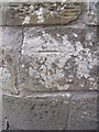
Benchmark on Pont Felin-Bache, Llangollen
This benchmark is located on the S parapet of Pont Felin-Bache on Bache Mill Road in Llangollen & it is shown in the current Ordnance Survey database at a height of 110.7095m above the Newlyn datum.
Image: © Meirion
Taken: 12 Jul 2011
0.03 miles
2
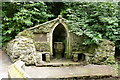
Valle Crucis Stone Font, Plas Newydd, Llangollen
A drinking fountain enclosed in a gothic shelter by the side of the stream within the gardens of Plas Newydd. The stone font was taken from the ruins of Valle Crucis Abbey, two miles away. The ladies of Plas Newydd were said to have influenced by the Christian Hirschfeld's book 'Theorie de l'art des Jardins' of 1779 in the laying out of their gothic garden.
Image: © Alan Terrill
Taken: 24 Jul 2013
0.04 miles
3
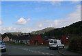
View north from Pengwern, Llangollen
View towards the Eglwyseg rocks and Dinas Bran castle.
Image: © Eirian Evans
Taken: 16 Apr 2011
0.06 miles
4
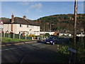
Houses at Pengwern
Mixed houses on the small estate on the edge of town.
Image: © John Haynes
Taken: 29 Nov 2007
0.07 miles
6
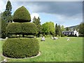
Topiary at Plas Newydd
Between the near and far topiary is what appears to be a 'gorsedd' circle of stones. These are used at eisteddfods.
Image: © Christine Johnstone
Taken: 13 May 2010
0.09 miles
7
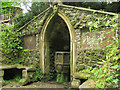
Plas Newydd - the grotto
Situated alongside the Cyflymen stream, the Grotto (also known as the Well House) was built in 1782 by Lady Eleanor Butler and Sarah Ponsonby using stone from the ruins of Valle Crucis Abbey. It is listed grade 2. There are inscriptions either side, the text of which can be read in the listing http://cadwpublic-api.azurewebsites.net/reports/listedbuilding/FullReport?lang=en&id=1133
Image: © Stephen Craven
Taken: 24 May 2017
0.11 miles
8
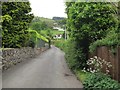
Grange Road, Llangollen
Heading out of town.
Image: © Stephen Craven
Taken: 21 May 2017
0.11 miles
9
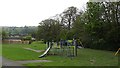
Playground, Brook Street
A residential area on the north facing slopes above Llangollen.
Image: © Richard Webb
Taken: 4 May 2012
0.12 miles
10
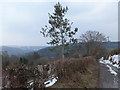
Young holly tree
This tree has been allowed to grow in a hedge that is mechanically trimmed.
Image: © John Haynes
Taken: 9 Apr 2013
0.12 miles