IMAGES TAKEN NEAR TO
Maes Mawr Road, LLANGOLLEN, LL20 7YW
Introduction
This page details the photographs taken nearby to Maes Mawr Road, LL20 7YW by members of the Geograph project.
The Geograph project started in 2005 with the aim of publishing, organising and preserving representative images for every square kilometre of Great Britain, Ireland and the Isle of Man.

There are currently over 7.5m images from over14,400 individuals and you can help contribute to the project by visiting https://www.geograph.org.uk
Image Map (Loading...)


Getting Data...Please wait
Leaflet Map data © OpenStreetMap
Images are licensed for reuse under creativecommons.org/licenses/by-sa/2.0
Notes
- Clicking on the map will re-center to the selected point.
- The higher the marker number, the further away the image location is from the centre of the postcode.
Image Listing (7 Images Found)
Images are licensed for reuse under creativecommons.org/licenses/by-sa/2.0
Image
Details
Distance
2
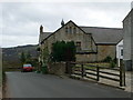
Converted Methodist Chapel in Garth
Built originally in 1847.
Image: © Eirian Evans
Taken: 21 Feb 2008
0.11 miles
3
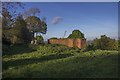
A relic from the forties
An old air raid shelter, once a familiar sight in the area, probably the last one remaining, just off the pathway to the Gronwen farm
Image: © Geraint Roberts
Taken: 15 May 2016
0.12 miles
4
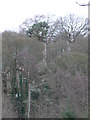
Tower Wood
You can just make out the "tower" of Tower Wood through the trees. This is Trevor Tower, a three-storey castellated tower built as a folly in these woods in the 19th C by a local landowner.
Image: © Eirian Evans
Taken: 21 Feb 2008
0.15 miles
5
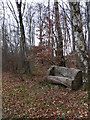
Rest a while in Tower Wood
Bench hewn out of a tree trunk.
Image: © Eirian Evans
Taken: 21 Feb 2008
0.17 miles

7
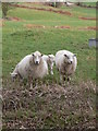
Protective mothers
Couple of sheep with their lambs west of Garth.
Image: © Eirian Evans
Taken: 21 Feb 2008
0.22 miles