IMAGES TAKEN NEAR TO
Jeffreys Terrace, LLANGOLLEN, LL20 7YS
Introduction
This page details the photographs taken nearby to Jeffreys Terrace, LL20 7YS by members of the Geograph project.
The Geograph project started in 2005 with the aim of publishing, organising and preserving representative images for every square kilometre of Great Britain, Ireland and the Isle of Man.

There are currently over 7.5m images from over14,400 individuals and you can help contribute to the project by visiting https://www.geograph.org.uk
Image Map
Images are licensed for reuse under creativecommons.org/licenses/by-sa/2.0
Notes
- Clicking on the map will re-center to the selected point.
- The higher the marker number, the further away the image location is from the centre of the postcode.
Image Listing (610 Images Found)
Images are licensed for reuse under creativecommons.org/licenses/by-sa/2.0
Image
Details
Distance
1
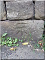
Benchmark on Gate Road, Trevor
This benchmark is located on the S side of Gate Road in Trevor & it is shown in the current Ordnance Survey database at a height of 78.0593m above the Newlyn datum.
Image: © Meirion
Taken: 13 Jul 2011
0.01 miles
2
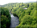
The River Dee seen from the Pontcysyllte aqueduct
Image: © Roger D Kidd
Taken: 19 Sep 2015
0.02 miles
3
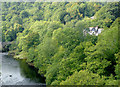
Woodland by the River Dee near Trevor, Wrexham
Image: © Roger D Kidd
Taken: 19 Sep 2015
0.03 miles
4
Llangollen, River Dee - 1984
The River Dee is a 110 km long river in the United Kingdom. It travels through Wales and England and also forms part of the border between the two countries. Pontcysyllte Aqueduct visible in the distance.
Image: © Helmut Zozmann
Taken: Unknown
0.04 miles
5
River Dee downstream looking towards Pontcysyllte aqueduct
Image: © John Firth
Taken: 10 Nov 2010
0.04 miles
6
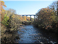
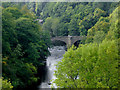
Pontcysyllte Aqueduct from Cysylltau Bridge
A dramatic view of the famous Aqueduct, from another historical bridge. The aqueduct crosses the River Dee.
Image: © Oliver Mills
Taken: 15 Aug 2017
0.04 miles
7
Valley of the River Dee
Taken from the Pontcysyllte Aqueduct looking West towards Llangollen.
Image: © Gordon Cragg
Taken: 14 Sep 2007
0.04 miles
8
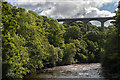
The Afon Dyfrdwy from the Pontcysyllte Aqueduct near Llangollen
The Cysalltau Bridge seen here carries Gate Road (B5434) across the river, left to Froncysyllte where inhabits the male voice choir of fame and renown! The aqueduct carries the canal 126 feet (38.4 metres) above the River Dee, allowing fantastic panoramic views all around. The colours here must be amazing in autumn.
Image: © Roger D Kidd
Taken: 20 Aug 2006
0.04 miles
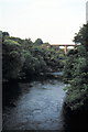
9
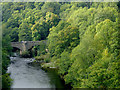
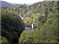
The River Dee south of Trevor, Wrexham
The bridge carries the B5434 road which links Trevor (and the A539) with Froncysyllte (and the A5).
Image: © Roger D Kidd
Taken: 19 Sep 2015
0.04 miles
10
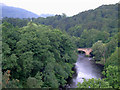
Woodland by the River Dee south of Trevor, Wrexham
The bridge carries the B5434 road which links Trevor (and the A539) with Froncysyllte (and the A5).
Image: © Roger D Kidd
Taken: 19 Sep 2015
0.04 miles