IMAGES TAKEN NEAR TO
Charles Avenue, LLANGOLLEN, LL20 7UB
Introduction
This page details the photographs taken nearby to Charles Avenue, LL20 7UB by members of the Geograph project.
The Geograph project started in 2005 with the aim of publishing, organising and preserving representative images for every square kilometre of Great Britain, Ireland and the Isle of Man.

There are currently over 7.5m images from over14,400 individuals and you can help contribute to the project by visiting https://www.geograph.org.uk
Image Map (Loading...)


Getting Data...Please wait
Leaflet Map data © OpenStreetMap
Images are licensed for reuse under creativecommons.org/licenses/by-sa/2.0
Notes
- Clicking on the map will re-center to the selected point.
- The higher the marker number, the further away the image location is from the centre of the postcode.
Image Listing (325 Images Found)
Images are licensed for reuse under creativecommons.org/licenses/by-sa/2.0
Image
Details
Distance
1

George Avenue, Trevor
The notice case contains documents posted by Llangollen Rural Community Council, including notice of a council meeting taking place on 6th November 2018! At least the early daffodils provide a touch of colour on this housing estate.
Image: © Stephen McKay
Taken: 19 Feb 2019
0.09 miles
2
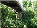
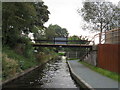
Llangollen Canal bridge no. 33W
This small cast iron bridge carries the Offa's Dyke Path over the Llangollen Canal. All bridges on the World Heritage Site have been retro fitted with cast plate numbers with an extra W.
http://www.offasdyke.demon.co.uk/
http://www.rcahmw.gov.uk/LO/ENG/Heritage+of+Wales/World+Heritage+Wales/
Image: © John Haynes
Taken: 22 May 2007
0.14 miles
3
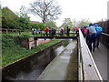
Croesi'r gamlas / Crossing the canal
Cerddwyr yn croesi'r gamlas ger Pont-Cysyllte.
Walkers crossing the canal near Pont-Cysyllte.
Image: © Alan Richards
Taken: 27 Apr 2019
0.14 miles
4
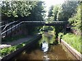
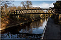
Postles Bridge (Bridge 32W), Llangollen Canal
This little footbridge crosses the Llangollen Arm of the Llangollen Canal just west of where this arm begins in Trevor. Note that although this final western section of the canal which heads to Llangollen from Trevor appears to be a subsidiary arm of the main canal, it is in fact the only continuation of that canal, as if you go straight on (northwards) at Trevor Basin you immediately enter the Anglo Welsh boatyard and the canal abruptly ends at a winding hole after Scotch Hall Bridge (Bridge 29W). This is because the original plan for the canal was to carry on past Trevor to northwest of Wrexham where it would have received its required water from a reservoir in Moss Valley. However this plan was abandoned as uneconomic, so water was still required to supply the canal and so this offshoot branch was constructed to Llangollen. As an eventual result, the canal is known as the Llangollen Canal, whereas originally it would have formed part of the Ellesmere Canal.
Image: © Rob Farrow
Taken: 23 May 2010
0.14 miles
6
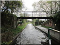
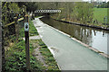
Bridge 32W, Llangollen Canal
A footbridge over quite a narrow section of the canal.
Image: © Richard Rogerson
Taken: 9 Sep 2014
0.14 miles
7
Llangollen Canal bridge No.33W
Cast iron bridge carries the Offa's Dyke Path over the Llangollen Canal.
https://en.wikipedia.org/wiki/Llangollen_Canal
Image: © Brian Deegan
Taken: 14 Dec 2018
0.14 miles
9
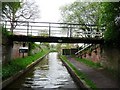
Bridge 32W, the Llangollen Canal.
Looking back towards Trevor Basin.
Image: © Christine Johnstone
Taken: 10 May 2010
0.15 miles
