IMAGES TAKEN NEAR TO
The Oaks, LLANGOLLEN, LL20 7TX
Introduction
This page details the photographs taken nearby to The Oaks, LL20 7TX by members of the Geograph project.
The Geograph project started in 2005 with the aim of publishing, organising and preserving representative images for every square kilometre of Great Britain, Ireland and the Isle of Man.

There are currently over 7.5m images from over14,400 individuals and you can help contribute to the project by visiting https://www.geograph.org.uk
Image Map (Loading...)


Getting Data...Please wait
Leaflet Map data © OpenStreetMap
Images are licensed for reuse under creativecommons.org/licenses/by-sa/2.0
Notes
- Clicking on the map will re-center to the selected point.
- The higher the marker number, the further away the image location is from the centre of the postcode.
Image Listing (16 Images Found)
Images are licensed for reuse under creativecommons.org/licenses/by-sa/2.0
Image
Details
Distance
1
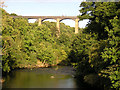
Just upstream from the Pontcysyllte Aqueduct
Image: © John Radcliffe
Taken: 3 Sep 2004
0.02 miles
2
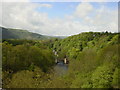
Dee Valley from Pontcysyllte Aqueduct
Looking 126ft down to the Dee Valley from the magnificent aqueduct which forms a key part of the Llangollen Canal, standing majestically at the foot of the Horseshoe Pass, three miles east of Llangollen. At over 1000 feet long, Pontcysyllte is the longest and highest cast-iron aqueduct in the world. Treasured by British Waterways, it is today a protected Grade I listed building, a Welsh National Monument and is one of the seven wonders of the British Inland Waterways System. It is of course still used for its original purpose, being crossed by more than a thousand canal boats a year. Pontcysyllte Aqueduct was designed by Thomas Telford. Construction started in 1795 and it was opened on 26th Nov 1805.
Image: © Sue Adair
Taken: 2 May 2005
0.02 miles
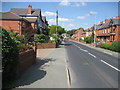
3
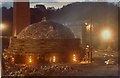
Trevor Brickworks
Taken not long before the site closed, it was derelict for many years and was developed into The Oaks housing estate.
Image: © Geraint Roberts
Taken: 20 Oct 2013
0.02 miles
4
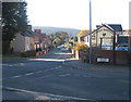
A539 passing the Aussie Rooster
Taken from the junction with the Garth road
Image: © John Firth
Taken: 10 Nov 2010
0.06 miles
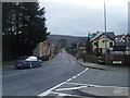
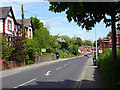
6
A539 in Trevor
Looking east along the main road into Trevor at the point where the Offa's Dyke Path meets from the south.
Image: © Chris Heaton
Taken: 27 Jul 2008
0.07 miles
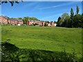
9

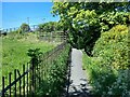
Footpath near Trevor
Leading to the Llangollen Canal.
Image: © John Lucas
Taken: 17 May 2016
0.16 miles