IMAGES TAKEN NEAR TO
Holyhead Road, LLANGOLLEN, LL20 7PT
Introduction
This page details the photographs taken nearby to Holyhead Road, LL20 7PT by members of the Geograph project.
The Geograph project started in 2005 with the aim of publishing, organising and preserving representative images for every square kilometre of Great Britain, Ireland and the Isle of Man.

There are currently over 7.5m images from over14,400 individuals and you can help contribute to the project by visiting https://www.geograph.org.uk
Image Map (Loading...)


Getting Data...Please wait
Leaflet Map data © OpenStreetMap
Images are licensed for reuse under creativecommons.org/licenses/by-sa/2.0
Notes
- Clicking on the map will re-center to the selected point.
- The higher the marker number, the further away the image location is from the centre of the postcode.
Image Listing (6 Images Found)
Images are licensed for reuse under creativecommons.org/licenses/by-sa/2.0
Image
Details
Distance
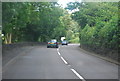
2
Old Milestone
Milestone on the A5 near to Garth, Denbighshire; for overall view see http://www.geograph.org.uk/photo/4713687
Image: © Keith Evans
Taken: 24 Oct 2015
0.08 miles
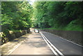
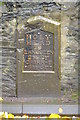
3
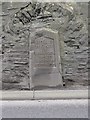
Old Milestone by the A5, Cwmalis, Vale of Llangollen
Telford Plate by the A5, in parish of Llangollen (Denbighshire District), Cwmalis, South side of road.
Inscription reads:-
HOLY-
HEAD
79
LLANGOLLEN
2M-2F
CHIRK-B
4M-5F
Carved benchmark on lower face.
Surveyed
Milestone Society National ID: DEN_HH79
Image: © Milestone Society
Taken: Unknown
0.09 miles
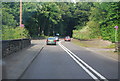
4
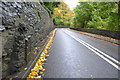
Holyhead 79
Milestone on the A5 near to Garth, Wrexham; for close up view see http://www.geograph.org.uk/photo/4713682
Image: © Keith Evans
Taken: 24 Oct 2015
0.10 miles