IMAGES TAKEN NEAR TO
Garth, LLANGOLLEN, LL20 7ND
Introduction
This page details the photographs taken nearby to Garth, LL20 7ND by members of the Geograph project.
The Geograph project started in 2005 with the aim of publishing, organising and preserving representative images for every square kilometre of Great Britain, Ireland and the Isle of Man.

There are currently over 7.5m images from over14,400 individuals and you can help contribute to the project by visiting https://www.geograph.org.uk
Image Map
Images are licensed for reuse under creativecommons.org/licenses/by-sa/2.0
Notes
- Clicking on the map will re-center to the selected point.
- The higher the marker number, the further away the image location is from the centre of the postcode.
Image Listing (5 Images Found)
Images are licensed for reuse under creativecommons.org/licenses/by-sa/2.0
Image
Details
Distance
1
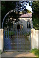
St Ffraid, Glyn Ceiriog
Pretty gate leading to the church of St Ffraid (St Brigid).
Image: © Eirian Evans
Taken: 21 Sep 2008
0.10 miles
2
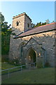
St Ffraid, Glyn Ceiriog
St Ffraid (Bridget)'s church is terraced into a steep hillside overlooking the valley of the Ceiriog some 6 miles west of Chirk. Although mentioned in the 13th century, it was rebuilt at the end of the 18thC.
Image: © Eirian Evans
Taken: 21 Sep 2008
0.10 miles
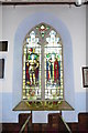
4
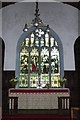
St Ffraid, Glyn Ceiriog
Stained glass window over the altar.
Image: © Eirian Evans
Taken: 21 Sep 2008
0.10 miles
5
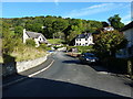
The upper end of Glyn Ceiriog High Street
Image: © Richard Law
Taken: 19 Sep 2017
0.24 miles