IMAGES TAKEN NEAR TO
Berwynfa, LLANGOLLEN, LL20 7HP
Introduction
This page details the photographs taken nearby to Berwynfa, LL20 7HP by members of the Geograph project.
The Geograph project started in 2005 with the aim of publishing, organising and preserving representative images for every square kilometre of Great Britain, Ireland and the Isle of Man.

There are currently over 7.5m images from over14,400 individuals and you can help contribute to the project by visiting https://www.geograph.org.uk
Image Map (Loading...)


Getting Data...Please wait
Leaflet Map data © OpenStreetMap
Images are licensed for reuse under creativecommons.org/licenses/by-sa/2.0
Notes
- Clicking on the map will re-center to the selected point.
- The higher the marker number, the further away the image location is from the centre of the postcode.
Image Listing (60 Images Found)
Images are licensed for reuse under creativecommons.org/licenses/by-sa/2.0
Image
Details
Distance
1
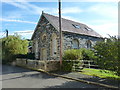
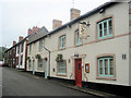
Former Salem Baptist Chapel in Glyn Ceiriog
Now converted to private residential use, but originally a Baptist chapel. The stone set high into the gable reads "Salem. Addoldy y Bedyddwyr Albanaidd. 1883" which I have translated roughly (and perhaps somewhat optimisitically) as "Chapel of the Calvanistic Baptists", ie the Scottish Protestant movement. If this is incorrect, please contact me and I'll update this description.
Image: © Richard Law
Taken: 19 Sep 2017
0.02 miles
2
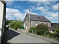
Glyn Ceiriog, former chapel
On High Street; formerly Salem Chapel, dated 1883, now residential.
Image: © Mike Faherty
Taken: 1 Aug 2017
0.04 miles
3
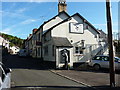
The Oak public house in Glyn Ceiriog
The landlord of the pub, changing the blackboard information, was clearly taken slightly by surprise to find himself being photographed this early in the morning. Sorry about that!
Image: © Richard Law
Taken: 19 Sep 2017
0.08 miles
4
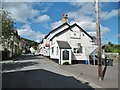
Glyn Ceiriog, Oak
Good Beer Guide-listed pub near the top of High Street; central bar, drinking area front, eating and drinking left and back on two levels; TV. Cask ale on offer at my visit: Stonehouse Station Bitter. Limited opening hours.
Image: © Mike Faherty
Taken: 1 Aug 2017
0.08 miles
5
Ysgol Cynddelw
Primary School at Glyn Ceiriog.
Image: © Eirian Evans
Taken: 19 Nov 2006
0.08 miles
6
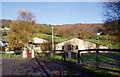
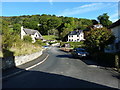
Heading upwards from the village of Glyn Ceiriog
A steep lane out of the village.
Image: © John Haynes
Taken: 9 Apr 2011
0.10 miles
7
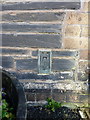
OS flush bracket G3014, Glyn Ceiriog
Flush Bracket G3014, affixed to the wall of the former Cambrian Inn, which is now a private house called Bryn Rhefail. Originally installed as part of the 3rd Geodetic Levelling survey of England & Wales in 1954, at which time it was levelled at 179.317m above Ordnance Datum Newlyn.
Image: © Richard Law
Taken: 19 Sep 2017
0.10 miles
8
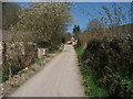
Looking back down the sunken lane
A well worn country lane looking back towards the grazings in Glyn Ceiriog.
Image: © John Haynes
Taken: 9 Apr 2011
0.10 miles
10
The upper end of Glyn Ceiriog High Street
Image: © Richard Law
Taken: 19 Sep 2017
0.11 miles