IMAGES TAKEN NEAR TO
High Street, LLANGOLLEN, LL20 7ER
Introduction
This page details the photographs taken nearby to High Street, LL20 7ER by members of the Geograph project.
The Geograph project started in 2005 with the aim of publishing, organising and preserving representative images for every square kilometre of Great Britain, Ireland and the Isle of Man.

There are currently over 7.5m images from over14,400 individuals and you can help contribute to the project by visiting https://www.geograph.org.uk
Image Map
Images are licensed for reuse under creativecommons.org/licenses/by-sa/2.0
Notes
- Clicking on the map will re-center to the selected point.
- The higher the marker number, the further away the image location is from the centre of the postcode.
Image Listing (65 Images Found)
Images are licensed for reuse under creativecommons.org/licenses/by-sa/2.0
Image
Details
Distance
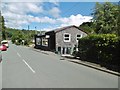
1
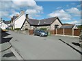
Glyn Ceiriog, former school
Former National School on High Street, with a plaque dating it to 1848; now residential.
Image: © Mike Faherty
Taken: 1 Aug 2017
0.01 miles
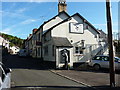
2
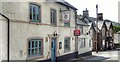
Y Dderwen, Glyn Ceiriog
It was closed as a pub when I took this photo. The sign says it's for sale.
Image: © Ian Hawfinch
Taken: 17 May 2018
0.02 miles
4
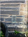
OS flush bracket G3014, Glyn Ceiriog
Flush Bracket G3014, affixed to the wall of the former Cambrian Inn, which is now a private house called Bryn Rhefail. Originally installed as part of the 3rd Geodetic Levelling survey of England & Wales in 1954, at which time it was levelled at 179.317m above Ordnance Datum Newlyn.
Image: © Richard Law
Taken: 19 Sep 2017
0.03 miles
5
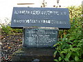
Ceiriog Memorial Institute - stone plaque outside the front
The plaque explains a little of the history and raison d'etre of the adjacent Memorial Institute building.
Image: © Richard Law
Taken: 19 Sep 2017
0.03 miles
6
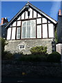
The Ceiriog Memorial Institute
Grade II* listed https://www.britishlistedbuildings.co.uk/300081286-ceiriog-memorial-institute-including-retaining-wall-and-railings-llansantffraid-glyn-ceiriog#.Wd8Lo_lSyM8 in 2003, the Village Institute was erected in 1911, partly as a memorial to local poets and artists, and partly as a celebration of Welsh culture. in its time, it's been a village hall, library, museum, court house, district office, women's parlour, and club with games room. Many of the museum artefacts have been moved to be displayed in Wrexham, having been donated to this building from all over the country and from the proud Welsh ex-pats of Patagonia.
Image: © Richard Law
Taken: 19 Sep 2017
0.03 miles
7
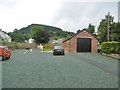
Glyn Ceiriog, engine shed
Shed once housing locomotives on the Glyn Valley Tramway, on New Road; now seat of the Glyn Valley Tramway Trust, and housing a small museum of tramway mementos; to the left, a reconstructed station, built on the original footings. The shed is listed by CADW: http://www.britishlistedbuildings.co.uk/300081292-locomotive-shed-glyn-valley-tramway-llansantffraid-glyn-ceiriog#.WYsN73UwgqA http://www.glynvalleytramwaytrust.co.uk/
Image: © Mike Faherty
Taken: 2 Aug 2017
0.04 miles
8
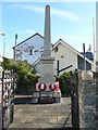
Glyn Ceiriog war memorial
Located in a small enclosure in the angle formed between New Road and the High Street.
Image: © Richard Law
Taken: 19 Sep 2017
0.04 miles
9
Glyn Ceiriog Christian Centre
On New Road; snacks, books and crafts on offer.
Image: © Mike Faherty
Taken: 1 Aug 2017
0.04 miles
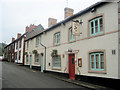
10
The Oak public house in Glyn Ceiriog
The landlord of the pub, changing the blackboard information, was clearly taken slightly by surprise to find himself being photographed this early in the morning. Sorry about that!
Image: © Richard Law
Taken: 19 Sep 2017
0.04 miles