IMAGES TAKEN NEAR TO
Fron Castell, LLANGOLLEN, LL20 7BX
Introduction
This page details the photographs taken nearby to Fron Castell, LL20 7BX by members of the Geograph project.
The Geograph project started in 2005 with the aim of publishing, organising and preserving representative images for every square kilometre of Great Britain, Ireland and the Isle of Man.

There are currently over 7.5m images from over14,400 individuals and you can help contribute to the project by visiting https://www.geograph.org.uk
Image Map
Images are licensed for reuse under creativecommons.org/licenses/by-sa/2.0
Notes
- Clicking on the map will re-center to the selected point.
- The higher the marker number, the further away the image location is from the centre of the postcode.
Image Listing (81 Images Found)
Images are licensed for reuse under creativecommons.org/licenses/by-sa/2.0
Image
Details
Distance
1
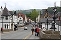
Llangollen: View south from the bridge
Image: © Dr Neil Clifton
Taken: 20 May 2016
0.01 miles
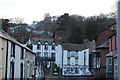
2
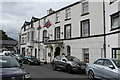
Llangollen: The 'Wynnstay Arms', Bridge Street
Image: © Dr Neil Clifton
Taken: 20 May 2016
0.01 miles
3
Llangollen: the 'Wynnstay Arms', Bridge Street
A no-nonsense pub with good ale and accommodation is available.
Image: © Dr Neil Clifton
Taken: 20 May 2016
0.01 miles
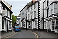
4
Llangollen
A5 Junction with Castle Street - looking East.
Image: © Chris Shaw
Taken: Unknown
0.01 miles
6
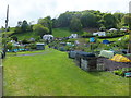
Llangollen allotment gardens
Well kept allotments that grow both flowers and vegetables.
Image: © John Haynes
Taken: 21 May 2016
0.06 miles
7
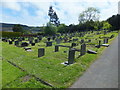
Fron-Bache Civil Cemetery
This part of this cemetery is still in use and is administered and maintained by Denbighshire County Council.
Image: © John Haynes
Taken: 21 May 2016
0.09 miles
8
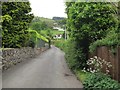
Grange Road, Llangollen
Heading out of town.
Image: © Stephen Craven
Taken: 21 May 2017
0.13 miles
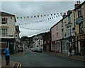
9
Looking out of town
If you in Llangollen and you want to go for a walk the only way is up, here looking outward from Heol Capal it can clearly be seen how quickly the ground rises on the south of the Town. The only level route is along the canal!
Image: © John Haynes
Taken: 1 Jan 2010
0.14 miles
10
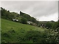
Field west of Grange Road
Showing the steep gradient of the hillside at this point.
Image: © Stephen Craven
Taken: 21 May 2017
0.14 miles