IMAGES TAKEN NEAR TO
Fron Bache, LLANGOLLEN, LL20 7BS
Introduction
This page details the photographs taken nearby to LL20 7BS by members of the Geograph project.
The Geograph project started in 2005 with the aim of publishing, organising and preserving representative images for every square kilometre of Great Britain, Ireland and the Isle of Man.

There are currently over 7.5m images from over14,400 individuals and you can help contribute to the project by visiting https://www.geograph.org.uk
Image Map (Loading...)


Getting Data...Please wait
Leaflet Map data © OpenStreetMap
Images are licensed for reuse under creativecommons.org/licenses/by-sa/2.0
Notes
- Clicking on the map will re-center to the selected point.
- The higher the marker number, the further away the image location is from the centre of the postcode.
Image Listing (33 Images Found)
Images are licensed for reuse under creativecommons.org/licenses/by-sa/2.0
Image
Details
Distance
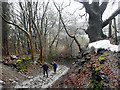
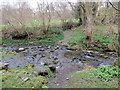
1
Ford and ancient route up the other bank
This ford is well made with large stones mixed with smaller pebbles and this provides a good surface making walking across in boots possible.
Image: © John Haynes
Taken: 19 Mar 2012
0.12 miles
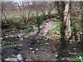
2
Discharge flume for small hydro scheme
The discharge flume for the spent water which is returned to Nant y Bache.
Image: © John Haynes
Taken: 19 Mar 2012
0.12 miles
3
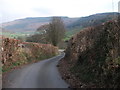
Lane at Fron-Bache
The lane has dropped 130m and is still heading down towards Llangollen. Good high hedges here, keep livestock in the fields and provide good wind breaks.
Image: © John Haynes
Taken: 12 Mar 2012
0.13 miles
4
Rhyd Cyflymen / Cyflymen ford
Hen heol (sy bellach yn llwybr) yn rhydio Afon Cyflymen. Yn ol map yr OS y mae pompren yn rhychwantu'r afon yn y lleoliad hwn ond nid yw hi'n bodoli bellach.
An old road (downgraded to a footpath) fording the Cyflymen stream. According to the OS Map there should be a footbridge spanning the stream at this location but it no longer exists.
Image: © Alan Richards
Taken: 27 Mar 2019
0.13 miles
5
Rainwater towards the bottom end of the Allt y Badi track
There are waterbars further up the steep track which attempt to divert runoff from the main path, but here it's being left to its own devices on the roadway.
Image: © Richard Law
Taken: 19 Sep 2017
0.13 miles
6
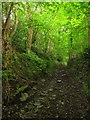
Allt y Badi
A steep byway through the woods. Described at each end as "unsuitable for motor vehicles", and they mean it! Image shows the same stretch of road looking in the other direction.
Image: © Stephen Craven
Taken: 21 May 2017
0.14 miles
7
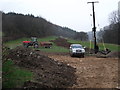
Final re-instatement
A small hydro electric scheme has recently been installed here and the top soil is being replaced over the pipeline scar. Meanwhile the final tidy around the generator shed is being completed.
Image: © John Haynes
Taken: 15 Mar 2012
0.14 miles
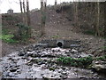
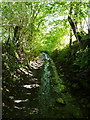
8
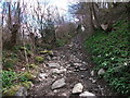
Ancient track
A track down to a ford and up the other bank.
Image: © John Haynes
Taken: 19 Mar 2012
0.15 miles
9
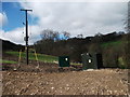
Small hydro scheme
The generator house, control box and grid connexion of a 100KW hydro scheme working on natural water flow with a head of 200m. Image]
Image: © John Haynes
Taken: 19 Mar 2012
0.15 miles