IMAGES TAKEN NEAR TO
Glyn Ceiriog, LLANGOLLEN, LL20 7AB
Introduction
This page details the photographs taken nearby to LL20 7AB by members of the Geograph project.
The Geograph project started in 2005 with the aim of publishing, organising and preserving representative images for every square kilometre of Great Britain, Ireland and the Isle of Man.

There are currently over 7.5m images from over14,400 individuals and you can help contribute to the project by visiting https://www.geograph.org.uk
Image Map
Images are licensed for reuse under creativecommons.org/licenses/by-sa/2.0
Notes
- Clicking on the map will re-center to the selected point.
- The higher the marker number, the further away the image location is from the centre of the postcode.
Image Listing (5 Images Found)
Images are licensed for reuse under creativecommons.org/licenses/by-sa/2.0
Image
Details
Distance
1
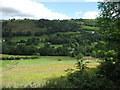
Ponies and buttercups
This farm is a pony trekking centre and all the fields are divided into smaller paddocks by means of ribbon electric fencing. Ungrazed fields are a mass of flowering buttercups just now (June).
Image: © John Haynes
Taken: 19 Jun 2012
0.15 miles
2
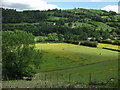
Mixed husbandry
Horses, sheep and pigs in three different fields, taken from the footpath on the south side of the valley.
Image: © John Haynes
Taken: 19 Jun 2012
0.16 miles
3
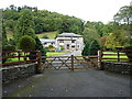
The Mansion House at Plas Wynne
A rather fine country house above Glyn Ceiriog.
Image: © Richard Law
Taken: 19 Sep 2017
0.17 miles
4
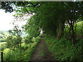
Glyn Ceiriog footpath
Footpath on the south side of Glyn Ceiriog.
Image: © John Haynes
Taken: 19 Jun 2012
0.21 miles
5
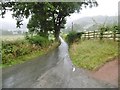
Glyn Ceiriog, Old Road
From Glyn Ceiriog to Dolywern; presumably pre-dating the current B4500 (New Road), on the other side of Afon Ceiriog.
Image: © Mike Faherty
Taken: 2 Aug 2017
0.24 miles